
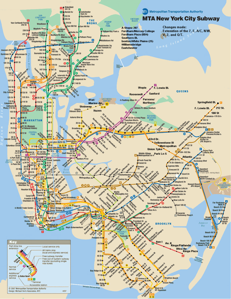
Every subway rider has his or her own vision for a better subway system. (Click here or on the image for guypak’s full version.)
Every few months, a thread such as this one pops up on the Straphangers Riders Diaries board or on Subchat. One person proposes the ways in which the New York City subway system could be extended to be a more inclusive system.
In the future MTA system linked above, the 7 goes beyond Main Street in Flushing and the F extends past its eastern terminus in Jamaica. The V journeys through a now-neglected part of Queens before meeting up with the A out to Far Rockaway. The 2 extends to Kings Plaza; the G permanently stops at Church Ave. (instead of its current planned temporary excursion into Kensington); the A runs a cross-Bronx line; and the N and W finally deliver subway riders to LaGuardia Airport.
While this map doesn’t include F/V express/local service in Brooklyn or the West Side extension of the 7 train, the 28 new stops would address many of the inadequacies of the current system, which, mind you, hasn’t been extended in over 80 years. Meanwhile, as we New York transit buffs dream of a future, plans for expansion seem noticeably off the table.
For the last few days, the MTA chiefs have been trying hard to justify a fare hike (and some pols think the MTA should just ask for more money from Albany). But in all of the talk of fare hikes, nary a word has been uttered about expanding subway service. Sure, the Second Ave. subway is under construction, but what about the rest of the city? At a time when the mayor is trying to push for fewer cars and better public transportation, more rail service is exactly what this city needs.
As a model for its expansion plans, New York City should look no further than London. While its taken more than 10 years to get this project off the ground, London Transport announced plans last week for the long-anticipated Thameslink rail project. The project will deliver more comprehensive commuter rail service through London. This includes a 300-percent increase in the number of trains reaching center London and an increase in the number of seats available during peak hours by 14,500.
The article contains a kicker that should ring some bells with New Yorkers:
Network Rail says the Thameslink upgrade is needed because 70% of all rail journeys begin or end in London and the south east and London’s population is projected to grow by nearly one million people in the next 20 years.
Those numbers sound suspiciously similar to Mayor Bloomberg’s estimates of the projected increase in New York’s population over the next 23 years. In London, the British are addressing projected population growth by preparing for it now. In New York, we’re sitting idly by while politicians whittle away the one good plan — congestion pricing — that would have boosted funds available for public transportation infrastructure. We’re not even considering increasing LIRR or Metro-North service either.
So as the fare hike debates heat up and the congestion pricing debates heat up, New York should turn to its sister city in the UK for inspiration. After 80 years of pining for a Second Ave. subway and a JFK Raillink, I would hope that the city would have learned its lesson. Planning now for the future seems obvious to me. Maybe we just need a reminder.
16 comments
Or just take a look at how New Jersey is expanding its rail system, by integrating most of the current lines, building new light rail lines, and proposing to build several new “regular” lines at the same time while barely hiking fares.
Very interesting and provocative map!
Im surprised., tho’, that it doesnt include the Bayridge Branch/NY Connecting RR, from the Brooklyn Army Terminal across Brooklyn (intersecting with practically every other line), joining the Canarsie Line then diverging to parallel the Metro Ave BMT Line and then, via now-unused trackage on the Hell Gate Bridge, serving Randall’s Island and thence into the Bronx.
I agree that New York should take its cue from London, which has continued to expand its mass transit system over the years.
However, most fan-fantasy maps are totally unhinged from reality, and this one’s no exception. The extensions of the 2, F, N/W and 7 are sensible, well known ideas that have been proposed before. But those oddly shaped A and V extensions are bizarre. They wouldn’t, and shouldn’t, be built. The extension of the C to 207th Street is entirely unsupported by real demand. In the meantime, improvements for which there IS real demand, like the Culver express and the 7 westward extension, aren’t shown.
Fan maps also tend to ignore less flashy improvements that would deliver real benefits, like reconfiguring Rogers Junction or building the Queens Boulevard super-express. The latter would almost certainly be needed before any of the lines on that corridor could be extended.
Incidentally, I see no evidence that the extension of the G to Church Avenue is intended to be temporary, despite the claim on one of the fan blogs that it is so.
Is this degree of expansion really financially feasible, or would we have to bear the brunt of an even bigger fare increase?
Victoria, capital improvements aren’t funded via the fare box, so I wouldn’t worry about that.
As I mentioned, the main problem is that fantasy maps are usually drawn from a railfan perspective, and aren’t tethered to any kind of feasibility or demand criteria.
Well even if the lines are built, they will not help the overcrowding on the Lex Ave and the 7th Ave Lines and the other lines. I envision a system where the F is extended all the way to Little Neck Pkwy… a line running elevated on Horace Harding Pkwy (maybe the median of the LIE)…a 10th Avenue subway, a 5th avenue subway… (relieving the choked 7th Ave and Lex Ave lines)…a Union Turnpike line… a Worth Street Subway…a Utica Ave line…allowing the N train to penetrate into East Queens…a Ft. Hamilton-Staten Island line as well as the F express.
They may not be built… but they can help relieve the overcrowded lines.
Marc: I agree with you. Many fan maps aren’t based completely in reality. However, the ideas – cross-Bronx service, more Brooklyn-Queens connection, service to LaGuardia, and service further out in the boroughs – are all things that should be implemented. How they are integrated into the current system is up to people with more power than I have (although Peter has an interesting idea up there).
The V extension on the map is the long-advocated restoration of the LIRR Rockaway Beach Branch right of way:
http://en.wikipedia.org/wiki/Rockaway_Beach_Branch
The Thameslink plan you link to is an upgrade. The current Thameslink was completed in 1990 and I took it in 2001; its essential feature is that it connects commuter trains from the north and south of London, allowing through-running and reducing the need for storage yards and cumbersome turn-arounds. In this way it’s similar to the Paris RER:
http://en.wikipedia.org/wiki/RER
What’s frustrating is that New York and New Jersey had a chance to create similar through-running systems when planning the Trans-Hudson Express tunnel and the LIRR/Grand Central and Metro-North/Penn Station links. Many of the lines have incompatible electrification systems, but it would certainly be possible to run trains from, say, Montclair to New Canaan without any modifications. Now the plan is to have both the LIRR/Grand Central and the THE tunnels dead-end in deep caverns without any possibility for extension. That’s forward thinking for you!
Contrast this with Peter Cooper, who incorporated elevator shafts into the plans for Cooper Union because he knew someone would invent elevators sooner or later.
Peter (the commenter above) does have an interesting idea. It’d be nice if he gave credit to the RPA folks who have been working on it for years:
http://www.streetsblog.org/200.....rtunities/
The V extension along the old Rockaway ROW is an old standby for rail buffs, who can’t stand to see unused tracks. Trouble is, the stations along the Rockaway peninsula are among the system’s least-used. It seems unlikely that the MTA would invest in a proposal that would, in effect, double their level of service.
It actually gets worse, because in the fantasy map the C goes full-time to Lefferts, and the A full-time to the Rockaways. So, counting the full-time a and the extended V, the Rockaway Peninsula would get something like 2½ to 3 times the service it has now. To repeat, these are among the least-used stations in the system.
Angus, et al –
Re: use of the Bayridge Branch for transit, I didnt credit RPA or anyone else, for the sake of brevity; Ive seen some plans for both transit & light rail conversion of that alignment, and air rights development of below-grade sections would go a long way toward making it economically feasible.
Certainly a look at the Subway map and knowledge of existing non-transit rights of way prompts speculation about which underutilized lines could be integrated into the transit system, and what exiting but separate lines could be connected for better coverage of the region.
The LIRR Rego Park-Rockaway Branch is one such opportunity posited in the expansion map, but others, like the Bayridge Freight Branch or the LIRR Montauk Branch were not explored. Use of the former LIRR Rego Park cutoff is technically feasible, but politically impractical due to opposition from neighborhoods through which would travel and, ironically, increase property values if built.
The question of whether any new line will serve an existing demand is the wrong question. The Flushing Line was built through an empty landscape and CREATED demand – for residential & commercial development.
The LIRR freight-only Montauk Line, a mere few hundred feet from the #7 at Crane St/Davis St. & Skillman Ave in LIC, traverses the dwindling industrial landscape of the Newtown Creek & Maspeth neighborhoods and is the key to revitalizing that part of the City. With few existing residential areas (and thus, voters to oppose it), it bisects one of the largest areas in the City bereft of transit. With the #7 & G at one end, it intersects the M in Middle Village, the ex-LIRR Rego Park-Rockaway Line and the J & Z in Woodhaven, reaching Jamaica Station and the E, J, Z as well as the benighted AirTrain.
Rather than railfan fantasy, existing RoWs offer practical ways to extend and expand transit service without financially improbable land acquisition and with relatively minimal construction costs and inconvenience.
Peter, I agree that transit can help revitalize neighborhoods (which is essentially Bloomberg’s argument for the westward extension of the #7 train). And I also agree that existing ROWs should be seriously considered, where there are other criteria that suggest the proposal makes sense.
But when I see a fan-fantasy map that proposes tripling service to some of the least-used existing stations in the system, I have to conclude that this is not a thoughtful plan overall. It’s just a rail buff drawing multi-colored lines for fun.
Goddamn Robert Moses
Peter, you make a good point about induced demand and property values, but it’s also important to keep perspective on where you create demand. Barrier islands aren’t a very good place for housing in general, and they’re particularly unsustainable with the threat of rising sea levels. I don’t think the government should subsidize any more development in the Rockaways than there already is.
On the other hand, instead of building an incompatible light rail system to serve JFK, we should have used the Rockaway Branch to bring subways from the Queens Boulevard line. The Rockaway Branch should be used for something.
In regard to the Montauk Branch, as I wrote in the comments to the Streetsblog thread that I linked above, if trains continue to terminate at LIC, then an increase in service won’t accomplish much. Better to use the eastbound loop and terminate at the planned Sunnyside station:
http://www.streetsblog.org/200.....ment-33397
As a Londoner, i’m flattered that a New Yorker would advise looking to London for public transport inspiration, but i don’t think there’s really much we can teach you. The last actual new underground line we opened was the Victoria line, in 1968. Apart; since then, in almost forty years, all we’ve done is:
– reopened the Snow Hill tunnel (part of the Thameslink route you mentioned) in 1988; built in the 19th century, but not used for passengers since 1916
– ‘built’ the Jubilee line, by taking over a 1930s branch of the Bakerloo line and extending it with 2.5 miles of tunnel from Baker Street (on the edge of the inner city) to Charing Cross (in the middle of the city) in 1979, and then another ten miles out to the City of London (the old financial district) and Docklands (the new financial district) in 1999
– built 19 miles of the Docklands Light Railway on old alignments and new routes through redeveloped areas
– built the Channel Tunnel Rail Link, a high-speed route from Kent to London, mostly in tunnel – although we don’t have anything except international services on it yet, and won’t for years, so it’s useless for anything except going to Europe
The Jubilee line extension was a pretty big deal, but the other stuff is not hugely impressive. It’s had a good bang for its buck, especially the DLR, but it’s small fry. The things we haven’t done are the major things we desperately need – new lines running east-west and northeast-southwest (or similar), which have been on the drawing board for decades. The east-west line, Crossrail, has now got government approval, but no work has started, and won’t for many years yet (until after Thameslink and the bloody Olympics are done). The Thameslink upgrade is grinding forward, but again is mostly minor improvements. Oh, and we’ve got an extension of the East London line in the works – but that’s rather like what i imagine the G train to be like, great if you need it, but not the solution to the city’s problems. It’s not a lot to show for 40 years.
I have no idea what New York has done in the last 40 years, but recently, you’ve actually broken ground on the Second Avenue Subway, which is your answer to Crossrail. You’re going to have trains running on most of it in ten years. We’re still going to be arguing about paying for our line then.
— tom
I don’t think running the A cross-Bronx like that is a good idea. Extending the C north like that isn’t a good idea also. Extending the V like that makes it look crooked. It is an upside-down U when the V can be extended like this: Have the V stop at Delancey St, East Broadway, York Street and Jay St. After Jay St, the V shifts to the Fulton Express track and merges with the A. The V runs express until Euclid Av. After Euclid Av, the V stops at Grant Av, 80 St, 88 St and Rockaway Blvd. The V continues to Lefferts Blvd. The A continues to Far Rockway while Rockway Park is served by the shuttle. The G should be extended the way everybody wants it to be with the F running express. The J/Z skip-stop service should be eliminated with running on the express track in a peak-hour mode.
The Second Avenue Subway plan is good, but I know how to make it better. The Q service is good, I’m talking about the T. Prepare yourself for this one: The T should have an extra stop at South Ferry to connect with the 1, N and W trains. There should also be a transfer to the 2 and 3 trains at Hanover Square. After South Ferry, the T should run high-speed under the New York Harbor to Staten Island. The first stop in Staten Island should be a station under a rebuilt St. George Terminal (With the SIR Station demolished.) After the St. George Terminal Station, the T rises to ground-level to run on the SIR tracks with fare control booths placed in every station.
The & extension should be extended south to 14th St. A free transfer should be built between Hewes St on the J and M lines and Broadway on the G line. The SAS should also be extended west under 125 St with stops at Lenox Av, Manhattan Av and Broadway. The 7 should be extended east to Bell Blvd via Northern Blvd. The Archer Avenue Line should be extended east to Springfield Blvd with the E being local and the J being express.
Sorry for the error but in the & extension, it should be the 7 extension.