Category: MTA Technology

  • Building a better countdown clock

    The MTA has added more useful information to its countdown clocks. (Photo by Rolando Pujol)

    As far as transit technology goes, the MTA’s shiny new countdown clocks leave much to be desired. While the authority now has access to tons of real-time information about train location, its only public presentation of that data is via the countdown clocks, and they suffer from a basic rudimentariness.

    The first problem I noticed with the new clocks concerned island platforms. At, for instance, Grand Army Plaza, the uptown and downtown trains pull in on opposite sides of the sole island platform, but the countdown clocks are for the entire station. If I’m heading to Manhattan, I don’t particularly care when the next Flatbush Ave.-bound 2 train is coming. Yet, that’s how the information is presented.

    The next complaint is one of design. Most of the signs rotate through only two trains, and it takes a concerted effort to find the next train at times. Furthermore, the green arrows are tough to read at a glance, and the destination indicators — which way is New Lots Ave.? — make a rider think too much about which train they need.

    That said, the MTA is not resting on its laurels. They’re upgrading the countdown clocks. In a release late Wednesday, the authority announced the UI changes. “To remove some of the confusion in the busier stations serving multiple train lines we have added express (EXP) and local (LCL) icons to help riders identify arriving trains,” the authority said.

    The PA/CIS signs now have a visual representation of the train direction. (Photo via New York City Transit)

    With 110 signs now up throughout the system, the authority has been able to see what works and what doesn’t. At stations with only one type of service and island platforms — generally express stops in Brooklyn or Lower Manhattan — the signs will differentiate between uptown and Brooklyn-bound service. The release explains the upgrades:

    Depending on the station configuration, signs will include direction and/or service type (express or local) information, as appropriate. So at Wall Street, only the 2 and 3 trains stop there—no locals. These are express trains traveling in different directions, so the signs only display uptown (UP) or Brooklyn (BKL). At 14th Street, the island platform is common for all trains going in the same direction so we show local or express.

    The addition of the icons is just a little bit more of a good thing for customers waiting for their trains. The changes were made initially at the Wall Street, 14th Street and 34th Street Stations on the West Side IRT. Stations were chosen where the Countdown Clocks are required to display multiple services and directions. The upgrade is also being performed at Chambers Street on the No.1 as well as Franklin Ave., Nevins Street and Grand Army Plaza in Brooklyn. The ability to include the additional information was available in the system and deployed at no additional cost.

    It’s a welcome change for a technology far too many years in the waiting. By the end of the year, all 153 stations will be equipped with the clocks, and then we wait for the B Division rollout, however that will look and whenever it will be. The next step though in the MTA’s technological renaissance will be access to real-time train location information. The countdown clocks might make our waits more tolerable, but knowing where a train is at what time would revolutionize trip planning across the city.

  • On the tensions between technology and transit

    TransportationCamp This weekend, I did something I haven’t done in years: I went to camp. This wasn’t my old sleep-away sports camp or the baseball camp I attended for years in the early 1990s. Rather, it was OpenPlans’ Transportation Camp, an unconference that gathered many of the sharpest minds working the transit and transportation space working on the side of the country.

    Now, the very idea of an unconference makes people raise an eyebrow. Shouldn’t conferences be structured with set agendas and leaders conducting the pace of things? In a society driven by open-source development and collaboration, a transportation unconference is an ideal format for people to meet and greet each other while bouncing ideas around. I met many readers there and many folks I read elsewhere. While San Francisco gets to enjoy a West Coast gathering next week, I’m already looking forward to next year’s event in New York.

    The sessions — which are listed here — were uniformly interesting. I sat in on a Q-and-A with MTA COO Charlie Monheim and US DOT’s Giovanni Carnaroli and Peter Appel. I met the gang from Greater Greater Washington, listened to a presentation on subway signaling and the PA/CIS system and checked out a discussion on matching service with demand. Other sessions — including those on taxi cab applications, road pricing and congestion alleviation — drew raves, but unfortunately, I couldn’t be in more than one room at a time.

    Throughout the weekend, the theme was clearly the interaction between technology and infrastructure, and although I missed most of Monheim’s keynote speech due to the MPRE, he hit upon a theme that bears discussion. While the MTA’s data leads itself quite easily to app development, there is an inherent incompatibility between the MTA’s system and technological investments. Last week’s stories on the supposedly obsolete fiber-optics network and the NYPD’s communications problems highlight that gap.

    Essentially, this conflict boils down as such: When the MTA purchases rolling stock and upgrades its physical plant, it expects its equipment to last for decades. Subway cars, for instance, have a shelf life of around 40 years before they’re up for replacing, and in the interim, it’s possible that hundreds of newer and better models have hit the rails since then. For better or worse, the same is true for major station renovations, signal upgrades and rail replacement projects.

    Meanwhile, when I purchase a new piece of technology, I expect it to last for four years, and I know it will be painfully obsolete by the time those four years are up. My laptop isn’t meant to last 40 years, and the technology behind it improves too quickly for it stay usable much beyond half a decade. For example, the software powering the R160 FIND displays will be obsolete long before the rolling stock is ready to be retired; in fact, the FIND displays have long since passed technological middle age. How then does a transit agency as extensive as the MTA incorporate rapidly-changing technology into a system built for long-term durability?

    This conflict is one with which the MTA must grapple on a regular basis. Take, for instance, the BusTime project. As the MTA moves forward with bringing the technology to more than just the B63, those behind the initiative are eying all 800 of Staten Island’s buses, and they hope to retrofit the buses and get the system up and running before the end of 2011. With over 6000 buses operating throughout the city, it’s not a surprise then that it takes a few years to get these wide-reaching technological initiatives up and running.

    From Transportation Camp, then, I drew the conclusion that transit agencies face two tasks when it comes to technology. They must make sure that the data these innovations produce gets into the hands of developers who can bring it to the public, and they have make sure that the innovations are compatible with infrastructure that will outlive the technology. What will happen to the countdown clocks in 10 years when they’re due for upgrades? What happens with those FIND displays as they age?

    We scorn the MTA’s on-again, off-again attempts to bring technology underground, but ultimately, it’s just not as easy as plug-and-play. As long as the developers have access to data though and the authority is willing to share the real-time information it produces, the public should benefit.

  • MTA’s fiberoptics network already obsolete

    Transit's new countdown clocks are a welcome addition to the system, but the technology infrastructure behind them is already out of date. (Photo via New York City Transit)

    The MTA’s not-so-new fibers optics-based communications infrastructure is already out of date even before the system is fully operative, the Daily News reports today. Work on the network, which cost $370 million is $76 million overbudget, first started in 2000 — eons ago in technology years — and will be completed later this year.

    The countdown clocks are its public face, but behind the scenes, as it improves internal communications and emergency response preparedness, the system already needs an upgrade. “Due to technology evolution and other factors, many components in this network are at or nearing their end of life,” one authority document obtained by the News says.

    Donohue has more:

    In the document, a request for information, the agency asked technology companies for advice on designing a “next-generation” communications network and fixing shortcomings with the existing one, which is up and running in much of the subway system.

    The MTA on Tuesday stressed the existing network – called ATM/SONET and designed by Siemens Transit Technologies – is functioning and carrying beneficial data, like next-train arrival times, at more than 100 stations…

    MTA documents say existing problems include:

    • Some of the equipment no longer is being made, which could make it more difficult and costly to maintain or upgrade.
    • The network may not have enough capacity for remote viewing of the growing amount of video from surveillance cameras.

    “This will put a large strain on [NYC Transit’s] current network, which was not originally designed to support the video capacity needs,” the October document states.

    The numbers on the cost overruns are both staggering and unsurprising. The first phase of the project is four years behind schedule and $36 million over budget. The second part will cost $40 million more than expected and isn’t delivering the same public benefits — in the form of countdown clocks — that Phase 1 provided.

    James Vacca, the chair of the City Council’s Transportation Committee, had some words to share. “Delays don’t just add millions of dollars to projects. They also lead to products that are obsolete even before anyone hits the ‘on’ switch,” he said. “That’s unacceptable.”

    The problem with any technology project is that the product is often obsolete before anyone hits the “on” switch, but in this case, the delays have led to litigation and headlines for years. Now, as Donohue notes, the promised safety benefits of this project may go unrealized without further investment. It is, in every sense of the word, one giant snafu.

    It’s worth noting too Vacca’s point. The MTA must get its capital house in order if it wants to find a way to fund the rest of the current five-year plan and close the $10 billion gap. When this project was first contracted out, Virgil Conway was the MTA Chair, and sense then, Peter Kalikow and Dale Hemmerdinger have come and gone. It’s tough to provide oversight with so much change at the top.

    This is exactly the situation though for which Jay Walder was brought to New York. The countdown clocks are a welcome addition to the system, but the technology behind it with its behind-the-scenes uses will have to be maintained and brought in line with current technology standards. That is so small task indeed.

  • The MTA’s escalator problem

    As we recently learned from Washington, D.C., transit agencies and escalators just don’t mix. Government agencies that are forced to take the lowest bids on projects often end up with escalators that can’t withstand the constant pounding they take, and fixes are costly and slow. The MTA too, as The Post briefly notes, has its own escalator problem, and agencies leaders are vowing to fix it. “I don’t think we’re providing the service,” Jay Walder said at the MTA Board meeting yesterday. “We have been trying a number of things on elevators and escalators, it’s not a budget issue, and they have not worked.”

    The MTA’s Transit committee meeting books provide a more nuanced look. Scroll to page 8-25 of this pdf for the full report. In essence, the MTA hopes for a 96 percent availability goal, but but 24-hour access is now hoving around 91.7 percent. That figure omits escalators targeted for capital replacement, and it doesn’t explore for how long these escalators are out of service. A quick glance at the Transit escalator outage page shows some that have been shuttered since late October and early November, and the one at High St., for instance, was available only 44 percent of the time last year.

    The systemic root of the problem seems to arise from technological failures and an inability to conduct efficient repairs, but that’s not stopping the MTA from expanding the escalator system. For instance, the current plans for the deep station at 34th St. and 11th Ave. along the 7 line extension call for only escalators — and no staircase access — at one end of the station. The MTA claims the depth makes a staircase inefficient, but I’ve often seen people walking up the flights at 63rd St. and Lexington Ave. Relying heavily on escalators though seems to be an avenue to inconvenience and steeper costs.

  • A crowdsourcing solution to subway tracking

    A few weeks ago, Alex Bell, the brother of a long-time classmate and baseball teammate of mine, e-mailed me about a project he’s working on. A lifelong New Yorker, Bell wanted to use something prevalent — smartphones — to track subway trains. Instead of a complicated and expensive technology solution to real-time train location systems, Bell believes he can, in his words, “use the sensing capabilities of the smartphone to map the current location of all the NYC subways in real time.”

    Enter the Subway Arrival Mobile Phone application. By using passive data and Base Station ID numbers, those who opt into Bell’s project can assist in providing essentially background data on train location. Bell pondered those who know where a train is when and determined that the short list includes the people on the train, the conductor, the MTA control room and, most importantly, those who have just gotten off the train.

    “In a perfect world,” Bell said to me, “all I would have had to do was write a simple application which let users broadcast that they had left such and such train heading downtown. But of course no busy New Yorkers would have engaged in that, which is called participatory sensing. Instead I had to devise a method of using opportunistic sensing — sensing that doesn’t involve the user.”

    To accomplish this, Bell focused on the BaseStation Identification number, which provides information on which cell tower is sending and receiving data to that phone. The application, he says, looks for periods of “no reception underground coupled with a large distance change.”

    “By using some signal processing algorithms the false positives are weeded out and the results are sent, anonymously, to a server,” he explained. “I have optimized the application to have almost negligible effect on battery life. And by keeping the data anonymous, the security concerns are removed.”

    This is crowdsourcing at its finest, and it just might work. To allow for differences in, say, walking speed or mobile signal pick-up, the application relies on a hidden Markov model to adjust the time variables. Of course, though, the app still relies on a critical mass of people to make it work. “As I have constructed it, when more and more users download the free application their phones will start reporting the location of the trains. The annotated Google Map, on both the phone and the website, will show icons which indicate which train and traveling in which direction,” Bell notes. “I may configure the server to also approximate arrival times; however, i think it may be more intuitive to see the icon approaching your station. The biggest IF I see is that if not enough users download the app then the data will be spotty and incomplete. Then users will delete the app before it had reached the critical mass of people to make it truly useful.”

    Recently, Bell has updated the map to include confidence intervals based upon the amount of data he has collected, and he is working on building an API so other developers can take advantage of the platform. Currently, Bell is maintaining a Twitter feed and is part of the NYC Big Apps competition. It’s certainly a solid idea behind a problem that has plagued the city’s subway system for years.

  • Great use of the MTA API or greatest use of the MTA API?

    Warning: F-word ahead: Making the rounds today is a website so pure in its simplicity that it needs no further introduction. Presented for your approval is IstheLtrainf**ked.com. It is the brainchild of Jonathan Vingiano, a programmer who often relies on the L train, and in a short post introducing the concept, he explains how he used the MTA API to provide real-time updates one everyone’s favorite subway line. “Almost every day,” he says, “I find myself asking one question: ‘Is the L train f**ked?’”

    As he explains how the site work, the post ends up being one praising the MTA’s new focus on working with developers. Vingiano, who posted his source code, writes, “The website’s info is no more than 60 seconds old and is a good way to find out if maybe you should be taking a cab home instead of waiting around for 45 minutes or so. The app is using the MTA’s official API (which is great btw), Sinatra, Heroku, and GitHub. These awesome tools let people like me release fun apps.” So there you have it. This is the MTA API at its most simple and direct. Would L train riders have it any other way?

  • B63 BusTime pilot officially live

    A screenshot of the landing page for the B63 BusTime pilot shows the buses along the route.

    New York City Transit has officially flipped the switch on its own in-house real-time bus tracking project. A few hours ago, its pilot program around the B63 — which I discussed in an in-depth exclusive this morning — went live. It’s now available at the MTA’s BusTime site, and the Developer API is ready to go as well.

    “Today, the transit system is quickly catching up with our 21st century expectation that real-time information is available on the go for all New Yorkers,” MTA Chair and CEO Jay Walder said in a statement. “That means knowing if your bus is on time before you leave home, getting updates on delays while you’re out and about, and unlocking opportunities for better service across our entire network. MTA BusTime is a big part of this new vision for bus service in New York.”

    By clicking on a bus, users can see how far away the vehicles is from its next stops.

    As I explained this morning, the new tracker, developed with OpenPlans, uses an open-source software program along with a GPS device with dead reckoning, an on-board wireless modem and an internal computer to keep tabs on the buses along the B63. The MTA is offering web- and text message-based tracking for buses and is working with merchants to install LCD signs displaying bus locations in real-team along the route. For customers used to frustratingly long waits for buses and glances down busy avenues, this should take the guess work out of waiting for buses that sometimes don’t show up at all.

    “We are working hard to provide up-to-the minute travel information for both bus and subway customers,” Transit president Thomas Prendergast said. “There are few things as frustrating as having to guess when the next bus is going to show up at your stop. With MTA BusTime, next bus arrival times are right in your hand.”

    If all goes well with the pilot, this system will be installed in all Staten Island buses later this year. For more from OpenPlans, check out their posting on the project.

    Selecting a particular bus stop shows how far away the nearest buses are.
  • Transit exploring glass doors for platform edges

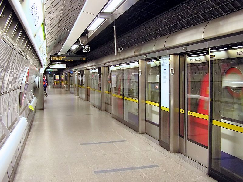
    Platform screen doors, such as those seen here at London's Westminster station, could soon come to New York's subway system.

    Transit is exploring the possibility of installing glass doors on its platforms to keep passengers safe, tracks clean and stations climate controlled, the Daily News reported today. With a recent spate of high-profile accidents involving straphangers who have fallen or were pushed into the tracks as well as concerns over debris in the tracks, the MTA is trying to focus more sealing off the station edges and are soliciting expressions of interest for plans to install platform screen doors, platform edge doors or a platform edge gate. They want, however, to find a project that involves “little or no upfront costs” to the authority, according to the Request for Information.

    “We are very early in the process,” Kevin Ortiz, Transit spokesman, said to the News, “of looking at the possibility of installing platform doors that would go a long way toward enhancing passenger safety and station appearance.”

    According to the RFI, Transit is looking for vendors who can a proposal with a variety of attributes. First, the authority wants something that won’t require service diversions to install, and they want a system that can be controlled remotely and opened in case of emergency. Due to varying car lengths on the B Division, Transit wants a system that can detect and respond to door placements.

    Learning from previous mistakes, Transit is searching for a system that requires “minimal preventative maintenance” that can withstand an “extreme operating environment.” The doors must be tamper and vandal resistant and must have space for informational displays and advertising posters. It must integrate well within the existing infrastructure and station technology and should be compatible with the various signaling and CBTC systems. The authority also said it will consider only venders whose systems that “have been proven in large-scale applications” in a “heavy-rail environment.”

    It’s hard to dislike this project. Doors would keep passengers safely away from tracks, allow for a more temperate station environment and keep garbage on the platforms where it is easier to clean. For the MTA, though, the key is cost. As I mentioned, the authority wants to pay as little as possible and could pursue revenue-sharing plans with the chosen vendor. Otherwise, this project, as previous MTA officials have warned, will be too expensive. Still, any excitement over this project may be a bit premature. The response to the RFIs are due in March, and the authority will then evaluate whether or not it wants to proceed with an RFP process.

  • Along the B63, an in-house real-time tracking solution

    The real-time tracking solution for the B63 has been developed in house by the MTA. (Photo by Benjamin Kabak)

    Within its 2011 agenda, the MTA promised to bring real-time bus tracking to every single bus under its purview on Staten Island. For those who have been charting the MTA’s bus-tracking project, this is a seemingly bold promise to put to paper. After fits and starts due to GPS compatibility issues, the authority had managed to install Clever Devices’ costly Bus Tracker program on only the M34 and M16, but the costs for that project proved too great for city-wide adoption. And so the MTA turned in-house for a solution.

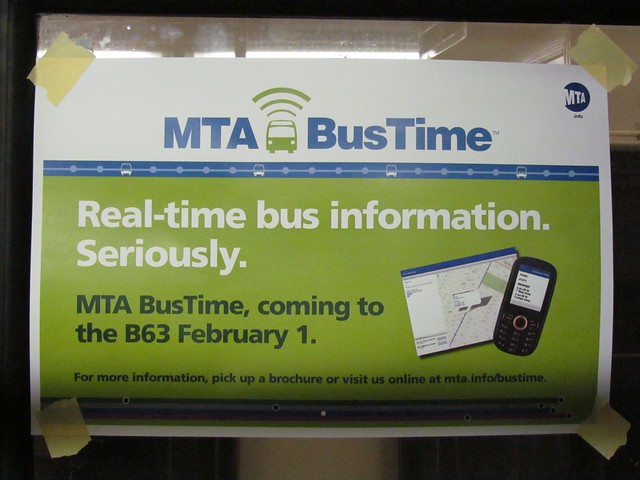
    This week, Transit will unveil that in-house solution, as the agency’s bus time tracking system will be live on the B63 in Brooklyn. The new system will follow buses as they run from Pier 6 at the Brooklyn Bridge Park to the southern terminal near the Verrazano Bridge and back. While the signs in the buses say the debut will be today, the official launch is still a few days away, and when the project is ready, it will be live on the MTA’s website at http://bustime.mta.info/.

    Last week, I took a tour of a bus at the Jackie Gleason depot with Michael Frumin, a senior strategic analyst with the MTA. Frumin, known for, among other things, his subway spark lines, has been working to develop an open-design approach to real-time tracking that comes at a lower cost than the Clever Devices’ implementation and allows the MTA more freedom with its data. He and I had a talk about the new bus tracking equipment and the MTA’s thinking behind an open source approach.

    The main problems with the Clever Devices’ system concern its proprietary nature and its cost. For the MTA to install Clever Devices’ computer, it must either upgrade old buses as a relatively high cost and maintain a closed computer network. At one point, the authority had estimated that it would take at least $140 million and five years just to install Clever Devices’ system through the city, and even then, the software and hardware handcuff the agency. Only Clever Devices can run software on its own hardware, and only Clever Devices can control the data flow. We’ve seen the limitations of the MetroCard technology, and the MTA wasn’t keen on pursuing a lengthy and expensive contract with another proprietary company.

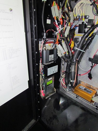
    So the MTA instead went the open-source route. Working with OpenPlans, the non-profit behind Streetsblog, on a $265,000 software-development contract, the MTA went about setting up its own system. On the hardware side, the set-up is simple. Using much of the same technology that will one day be installed as card readers for the next-generation fare payment technology system, the bus tracking uses a wireless moden, a power conditioner, a highly-secure on-board computer and a GPS device with dead reckoning to track the bus.

    A glimpse at the technology behind the MTA's new BusTime set-up. The GPS device, right, hooks into an internal computer with a power conditioner and wireless modem. (Photo by Benjamin Kabak)

    At the outset, the device relies on the driver to input data that he must input at the start of every route and when the bus turns around. By hooking the computer up to the bus route sign, the bus’ initial direction is sent to the software. For example, when a B63 leaves the Jackie Gleason Bus Depot and the driver arrives in Ft. Hamilton, he’ll set the sign to say that the B63 is Cobble Hill-bound. The internal computer will read the direction, and with data from the GPS, it can calculate the direction and location of the bus as it travels its route. The Clever Devices’ system relies on schedule data and other complex calculations to derive location.

    Of course, as with any less expensive and open system, the data won’t be as complete as that offered by Clever Devices. With its in-house bus tracker, the MTA can present at the outset how far away the bus is from its location but not how many minutes away from a certain stop the bus will be. Frumin told me that it is a goal to develop an accurate prediction algorithm for travel times.

    Meanwhile, because this new system is open-source, the MTA can open it up to developers. It will issue an API and allow New York’s myriad transit programmers to take a crack at the data. Frumin spoke to me about possible uses. Someone could develop an SMS alert system or a do-it-yourself countdown clock that auto-refreshes based on the BusTime information. CEMUSA, the owner of the bus stops, could, for instance, install its own timers even as the data remains available online. Essentially, with this open source approach, when you need to add features or want to borrow what others are doing, it’s quite easy.

    A screenshot of the B63 BusTime tracker as it will appear online. At press time, a larger image was not yet available.

    So what’s next? It seems clear that while the internally developed BusTime will make its debut in Brooklyn, Staten Island will be the real testing ground. Can an entire borough’s bus fleet be viewed at one time? Will the MTA run into GPS-based problems as it eyes Manhattan? Dead reckoning should fix that problem, but it’s much easier to implement location-based technology along 5th Ave. in Brooklyn than along 5th Ave. in Manhattan.

    For now, though, we’ll see in-house development in action. The MTA will have the chance to show us that it can develop real-time tracking for cheaper than a closed-source market leader. For a giant transit provider seemingly afraid of technology five years ago, that is a step in the right direction.

  • Transit marks 100th IRT station with countdown clocks

    When New York City Transit announced plans to install countdown clocks at 75 stations along the IRT numbered routes this year, most MTA watchers scoffed at the lofty goal. The MTA has long had problems bringing technology innovation to its 105-year-old system, and other subway systems had been enjoying the benefits of countdown clocks for decades. Well, today, the authority announced that it has exceed this goal by 25. When the countdown clock at Houston St. on the 1 went live this week, it was the 100th installed in 2010.

    No longer will riders impatiently tap their feet while seeking out the dim glow of an advancing train piercing through the darkness of a tunnel. “For years, transit riders in other cities around the world have been looking at digital signs to know when the next bus or train is coming,” MTA Chairman and CEO Jay H. Walder said. “But in New York, we were left peering down a subway platform looking for headlights. We’re changing that and improving our customers’ experience one station at a time.”

    The MTA anticipates that the full rollout along the numbered lines will be completed by mid-2011. At that point, the authority will assess ways to bring this technology to the B Division lettered lines. “This is all about providing information to our customers who may see similar systems in other locations and ask, ‘Why not here?’ Well, we asked ourselves the same thing and we are now moving briskly ahead with this project,” NYC Transit President Thomas Prendergast said in a statement. Even as the MTA faces precarious financial times, it’s good to see forward progress.