When the Nets new arena opens at the Atlantic Yards complex in a few years, it will bring with it traffic to a few of Brooklyn’s quieter residential neighborhoods. With Park Slope to the south, Prospect Heights to the east and Fort Greene to the north, the area doesn’t lend itself to the multitude of cars that will throng its streets on game days. Unfortunately, despite sitting atop one of the city’s busiest subway hubs and a Long Island Rail Road, the project will come with more parking than we’d like. To encourage mass transit use then, one advocate has proposed an idea for the masses: free beer.
At a Prospect Heights Neighborhood Development Council meeting held last week to attack the traffic problem, Ryan Lynch of the Tri-State Transportation Campaign called upon Forest City Ratner to subsidize a free beer for those who take the train to the game. “Give people a free beer. They’re not driving,” Lynch said. “There needs to be more incentives from the developer and events promoters to encourage event-goers to get on mass transit. You could show your Metrocard or LIRR ticket and get a discount at the concession stand.”
A spokesman for the developers issued a very spokesman-y statement. “We’re working on a fully integrated transportation plan that will look at a variety of ways of using mass transit instead of driving to the arena on game nights or event nights,” Joe DePlasco said. Ultimately, though, the Nets and Forest City Ratner should figure out a way to encourage transit use. Whether that includes supporting a residential parking permit program for the neighborhood’s streets or offering MetroCard- and LIRR-based discounts, driving to this arena should be discouraged. I’d drink to that.
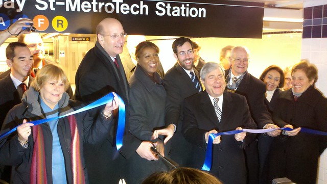
MTA CEO and Chair Jay Walder, with scissors, celebrates the opening of the new station as Brooklyn politicians join in. (Photo by Benjamin Kabak)
At the ribbon-cutting ceremony celebrating the completion of the Jay St.-MetroTech station rehab and a new connection between the IND and BMT, MTA officials spoke of the thousands of people who will now enjoy the new station. For the first time since 1933, passenger will enjoy a free in-system transfer between the R and the A, C and F trains. It was a distance of barely more than 100 feet that took nearly eight decades to bridge.
“The work we’ve done here acknowledges this station’s importance to Downtown Brooklyn,” Transit president Thomas Prendergast said to a crowd of contractors, politicians and reporters at the station this morning. “From day one, this is going to be a vital transfer point for our customers, creating another transit hub in Downtown Brooklyn.”
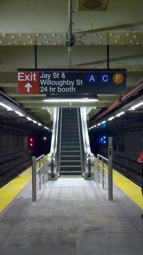
A new escalator leads the way up from the old Lawrence St. station on the R. (Photo by Benjamin Kabak)
With the new connection comes a new name, and while the signs across the complex now say Jay St.-MetroTech, it might be tough for the locals to forget about Lawrence St. and Borough Hall. Still, a new moniker is nothing compared with the overall enhancements at the station. Jay St. is now fully ADA-compliant with three elevators and two new escalators. The fare control areas have been reorganized to better facilitate passenger flow, and a massive Arts for Transit installation adorns the mezzanine level.
“We don’t just do the bare minimum,” MTA CEO and Chair Jay Walder said. “We put in the work, effort and art that will allow us to walk in here and smile when we enter the station.”
For the MTA, this connection is, as Walder says, part of an effort to “correct[] a mistake that was made back in 1933.” As the original tripartite subway system went up, lines operated by different companies crossed, but because of the competition between the IRT, BMT and IND operators, transfers were often omitted. Now, with various projects around the city, the MTA is working to integrate an old system. “The opening of this link as well as two other new transfers to be placed into service next year continues the physical consolidation of a subway originall built and operated as three separate systems,” Prendergast said.
The politicians who took part in the ceremony echoed this drive and pushed for more. Letitia James, City Council representative for the area, called upon the MTA to connect the G with the IRT. Both Borough President Marty Markowitz and Joan Millman, while praising the MTA for finishing the $164 million rehab on time and under budget, urged the authority to address the issues surrounding the former Transit headquarters above. “370 Jay Street,” Markowitz said. “That’s our next chore.”
This morning, they celebrated. This afternoon, they went back to work. “Finally,” Markowitz said, “we have a station worth of Downtown Brooklyn and all Brooklynites.”
Departures and Arrivals fills an artistic gap Departures and Arrivals (2009), Ben Snead, Jay Street-Metro Tech Station, A, C, F, R lines, MTA New York City Transit. Commissioned and owned by Metropolitan Transportation Authority Arts for Transit. (Photo: Collin LaFleche. Click to enlarge.)
As part of the station rehab, the MTA’s Arts for Transit division has installed a 103-foot-long mural along the newly renovated mezzanine. Designed by Ben Snead, the piece is called Departures and Arrivals, and it is a metaphor for the melting pot of the Borough of Kings. It features species of animals that have migrated to Brooklyn and one that is departing.
Snead, who works extensively with animals, had applied to design an installation for two other stations in the Bronx, but the MTA finally came knocking for the space at Jay Street. It is, Lester Burg of Arts for Transit told me, one of the largest installations in the system. It is made out of glass mosaic and ceramic title, and it undulates as the wall does. The art adds another welcoming touch to a station much improved.
After the jump, a slideshow from the unveiling.(more…)
Where: On the platform at the station currently known as Jay St. – Borough Hall
Via loyal SAS reader Jeffrey, who sent this photo in via his Twitter account, comes a snapshot of things to come in Downtown Brooklyn. As I reported over the weekend, the connection between the Jay St. – Borough Hall stop on the A/C/F and the Lawrence St.-MetroTech station on the R will open at 1 p.m. tomorrow, and the MTA wants everyone to know about the station’s new name. I’ll be at the ribbon-cutting in the morning, and I’ll try to take some photos of the new passageway. So far, all we’ve seen is a video. The changes should be reflected on the subway map in the upcoming weeks.
As far as minor subway construction projects go, none generate more interest among riders than the long-awaited transfer between the 7 at Court House Square and G at Court Square. The project was supposed to be completed in early 2010, and it has stretched ever onward. Today, though, NY1’s John Mancini brings word that the connection will finally open in February. Riders will now have an in-system transfer between the E, M, G and 7 and will no longer have to cross Jackson Ave. or pay two fares.
Meanwhile, Mancini tells us that another new subway connection — the pedestrian tunnel between Jay St. and Lawrence St. in Downtown Brooklyn — will open on December 10, ahead of schedule. This new transfer point between the A/C/F and R trains is part of a $108 million rehab of the Lawrence St.-MetroTech and Jay St.-Borough Hall Stations. When the project is completed, the new station complex will be called Jay St.-MetroTech. For a video on the new transfer point, check out this July post. Now if only Transit would connect the L and 3 trains at Junius and Livonia.
Could a solar-panelled canopy cover the BQE Trench? (Courtesy of Starr Whitehouse)
New York City has long had a love/hate relationship with the BQE. Built by Robert Moses, the road is dug into a trench along Hicks St. in Carroll Gardens. This cacophonous highway has cut off much of Brooklyn from the waterfront district and created an array of dead-end streets and constant pollution. While some city planners would love to bury the BQE underneath Brownstone Brooklyn, a new plan to green the Carroll Gardens trench and reconnect the disjointed neighborhoods is gaining steam.
Last week, the Economic Development Corporation presented three proposals to better integrate the BQE trench into the surrounding area. The plans range in price from $10 million to $85 million and include a focus on green energy. If implemented, they would truly beautify an ugly part of the eastern edge of Brooklyn.
Developed by Starr Whitehouse Landscape Architects and Planners, the plans are as follows:
Maximum Green: For $10-$18 million, the city would plant 412 new trees along the trench that would “help buffer the mayhem below.” Plans also include a market at Union St. and sound barriers.
Connections: For $20-$45 million plus an additional $123,000 in annual upkeep, the city would build six pedestrian and bicycle bridges over streets that dead-end at the BQE. Those streets included Warren, Baltic, Degrew, President and Carroll.
Green Canopy: The $85-million proposal is of course the most luxurious. As The Brooklyn Paper’s Gary Buiso describes: “A latticed, steel canopy is constructed over the trench to shield the view of traffic and provide environmental benefits by reducing noise and creating its energy from the sun, thanks to photovoltaic panels. Retail uses are also possible at Union Street, including an aptly named Trench Café.” Upkeep on this canopy would cost $477,000 a year, but it would offset costs by generating at least $300,000 in solar energy.
For improved access and safety, six pedestrian and bicycle bridges could span the BQE. (Courtesy of Starr Whitehouse)
From the outset, the city raised immediate concerns about the cost of both installing these green projects and maintaining them. “This would be a challenge to maintain additional bridges,” DOT’s Christopher Hrones said. “We think this is compelling, but we are clear that maintenance funds have to come along with this to make it successful.”
Brad Lander, though, the councilman for the area, believes in the project. “It’s not just a pipe dream,” he said. “We can work to make it happen.”
Essentially, the EDC and the neighborhood groups are hoping to achieve five goals for an area whose growth has been stunted by the highway that passes through it. The ideal project will feature noise reduction, pollution mitigation, beautification, improved connectivity and pedestrian safety. The BQE, which is a testament to a time in which Moses was allowed to build without regard for surroundings, has long been a blight on Brooklyn, but perhaps, if the money materializes, access to the waterfront will improve as an ugly trench turns into a swan. It might not be a plan as dramatic as a tunnel, but it’s far more feasible.
For just $10 million, trees planted along the Hicks St. trench could beautify the area. (Courtesy of Starr Whitehouse)
Here’s an intriguing announcement that came out of today’s MTA Board committee meetings: Transit is restoring bus service through the MetroTech complex in Downtown Brooklyn for the first time since Sept. 11, 2001. The agency press release notes that “due to security measures adopted by the New York City Police Department following 9/11,” Transit had to reroute the B54 around the MetroTech Center, but now that the tenant that “required these security measures” is vacating the area, the B54 will resume service through the center.
The new routing will remove the B54 from the Flatbush Ave. extension and Tillary St. and send the bus down MetroTech Walk instead. The MTA believes this change will “improve reliability and provide a more direct route” for those traveling to the subway. The stops along Jay St. at Tillary St. and Mrytle Ave. will be discontinued, and the B54 will stop at MetroTech walk and Lawrence St.
Speaking of the subway, The Brooklyn Paper speaks with Transit officials this week about the upcoming renaming of the Jay St./Borough Hall subway stop. When the extensive renovations are finished within the next few months and the Lawrence St. R stop connects with the A/C/F station at Jay St., the complex will be renamed Jay Street-MetroTech. “The Jay Street station is much closer to MetroTech than it is to Borough Hall,” Deirdre Parker, Transit spokesperson, said to the paper. “So the entire complex, including Lawrence Street, will be called Jay Street-MetroTech when the project is finished.”
Last week, I reported on a trolley-based transit-oriented development plan for Red Hook and the Brooklyn waterfront. Spurred on by years of advocacy by the Brooklyn Historic Railway Association, the NYC Department of Transportation will spend $500,000 on a feasibility study that will examine a proposal to send a trolley from Downtown Brooklyn to Red Hook via Atlantic Ave. and Columbia St. For an area of Brooklyn that doesn’t enjoy ready access to the subways, such a route could connect a disconnected neighborhood.
While a streetcar nostalgia with an emphasis on 21st Century transit-oriented development appeals to some, others see the flaws in the BHRA’s plans. Over at The Transport Politic, a site that has long advocated for an extensive Brooklyn streetcar network, Yonah Freemark questions the city’s goals here. Latching onto the aspect of the BHRA proposal that would restore old trolleys to the borough’s streets, Freemark condemns the plan: “These mobile museums are more about tourism than they are about meeting typical commuting needs. Unlike modern buses, these old streetcars are not handicap-accessible, nor are they air conditioned. Even more problematically, they often carry fewer passengers than the buses they’re supposed to replace.”
On a macro scale, Freemark wants the city to address some fundamental questions: ” How can the existing transit network be improved? What routes are missing or need to be reinforced? Where should future development be oriented?” Basically, he says, “if streetcars cannot provide improved operations over typical buses, why should cities spend millions of dollars installing them?” With an appropriate nod to Bob Diamond’s tireless and badly-needed advocacy work, Freemark notes that streetcars can certainly be useful in improving transit access, but a modern rolling stock and a sense of purpose behind the route might be required before the city should restore streetcars to Brooklyn.
The Brooklyn Historic Railway Association’s trolleys, seen here at the Brooklyn Navy Yard, disappeared without a trace in sometime after mid-2005. (Photo via BHRA)
For decades, the word Brooklyn was synonymous with the trolley. Throughout the early years of the 1900s, the borough became known for its extensive streetcar system, and its baseball team now the property of Los Angeles still carries with it shortened form of the Trolley Dodger. Ripped up by the auto industry in the 1950s, the trolley tracks remain a buried part of Brooklyn’s past, but now they could be inching closer to being a part of the borough’s transportation future as well.
The New York City Department of Transportation and House Representative Nydia Velazquez announced yesterday evening a new feasibility study that will explore a long-proposed trolley route in Brooklyn. The URS Corporation will conduct a five-month study on a route that would run from Ikea in Red Hook to either Atlantic Ave. at Pier 6 of the new Brooklyn Bridge Park or the Borough Hall subway stop. The study will cost $295,000 and will be funded by a grant Velazquez has had in her pocket since 2005.
“A streetcar system in Red Hook has the potential to reconnect this neighborhood with the rest of the city and greatly improve transit options for residents,” the Congresswoman said. After the study, DOT plans to meet with local groups to explore how a streetcar route would impact the neighborhood.
This announcement is not without controversy however. It stems from a long-standing dispute between the Brooklyn Historic Railway Association, New York City and Representative Velazquez. Over ten years ago, the BHRA received approval and funds to establish a streetcar route from Red Hook to the Borough Hall subway stop. They built part of the route on private land and purchased 17 streetcars, some of which remain parked behind the Red Hook Fairway today.
But after Phase I — the private construction — wrapped, the city pulled the plug on the project and revoke the consent it had granted BHRA. Bob Diamond, the group’s head, was rightfully outraged, and a long-term standoff followed. Velazquez succeeded in securing the grant nearly half a decade ago but refused to release the funds for a feasibility study. The streetcars languished in storage in the Brooklyn Navy Yard and then disappeared without a trace in mid-2005. Diamond grew frustrated with the city and as a recently as last week, threatened to cease his Atlantic Ave. subway tours, close up shop with the BHRA and leave New York.
Since that flurry of press coverage over Diamond’s outrage, the city has seemingly embraced the streetcar idea, and the study will proceed apace. Velazquez has requested $10 million in funds for construction of a Red Hook route, and the money is pending approval in the House. Considering the state of Congress and the upcoming midterm elections, that grant is no sure thing, but the politicking behind this plan is moving forward.
So what then would the trolley route look like? Diamond and the BHRA recently published an updated route to include the new Ikea and other destinations in Red Hook. Click the image below for more details.
The questions harder to answer are the ones URS will examine. Someone will have to be best positioned to own and operate this trolley route, be that the MTA, NYC DOT or a private group. URS will have to determine the operational and maintenance costs and whether or not this route would enjoy ridership. It will explore demographic and economic development data as well as current transit patterns and needs. It will assess technology and construction issues as well as the economic impact a streetcar route would have on the neighborhood.
As BHRA is pushing the street car as an impetus behind transit-oriented development, the Columbia Street waterfront and Red Hook could use better public transit access. Still, as presented this streetcar plan is only slightly more than a glorified feeder route that would mirror a bus route and deliver residents to a subway route. Progress, though, is progress, and it’s about time that Velazquez’s office release the money for the study. It might not lead to a new borough-wide trolley network, but it is forward progress nonetheless.
The proposed Second System subway expansion plans issued in 1929 called for subway lines down Nostrand and Utica Aves.
In the annals of New York City subway history, the Second Ave. Subway carries with it the grand stigma of futility. First proposed in 1920, the SAS went through various iterations, groundbreakings and funding crises before the current construction efforts relaunched in 1995. Barring an economic catastrophe, at least Phase 1 of the Second Ave. line will open before the end of the decade, and the Second Ave. Subway will pass from myth to reality.
Elsewhere, though, other subway expansion plans have languished for nearly as long as the Second Ave. Subway. While none of these plans have as tortured a history as the future T line does, many of them are common-sense system expansions that have been on and off the city’s transit table since the early days of New York’s subway system. Take, for instance, the Marine Park-Sheepshead Bay-Gerritsen Beach area.
Although Brooklyn’s subway service is nearly as comprehensive as Manhattan’s, a glance at the borough map reveals a large gap in service in the southern reaches of eastern Brooklyn. The Marine Park-Sheepshead Bay-Gerritsen Beach triangle is serviced only by the B and Q along Flatbush Ave. to the west and a bunch of local buses. To the north, the Flatbush Ave./Brooklyn College stop serves as a terminal for the 2 and 5 trains, and with Nostrand Ave. running south from that station, that road would serve as the natural starting point for new service.
In fact, that’s long been the dream of city planners, and that final stop on the 2 and 5 wasn’t built as such. Rather, it was supposed to lead into the Nostrand Ave. subway line. Talk of the Nostrand and Utica Ave. subway extensions pop up as early as 1910 when The Times discusses future expansion of the young system into Brooklyn. A century ago, planners anticipated a branch of the subway running out to the ocean, and the IRT awarded its Brooklyn expansion plans in two contracts. Only the first part saw the light of day, and when Flatbush Ave./Brooklyn College opened in 1920, no one knew this station would become the de facto terminal for the IRT.
In 1929, when the city unveiled its ambitious Second System proposal, both Nostrand and Utica Ave. extensions were included. The Nostrand spur would have completed the IRT’s early 1910 plans for subway expansion, and the Utica Ave. route would have been the southern part of the new Williamsburg train lines. A 1939 post-Depression version of the Second System had the Utica Ave. line reaching Floyd Bennett Field.
The 1939 plans for subway service to Floyd Bennett Field.
As we know from the history of the Second Ave. subway, though, a World War interrupted the city’s ambitious expansion plans, and the Nostrand and Utica subway lines were once again shelved for nearly 15 years. As the mid-1950s dawned and the city looked to build the Second Ave. line, so too did it give approval for the Nostrand and Utica Avenue extension plans. The Nostrand spur would again see what we now call the 2 and 5 extended south while the Utica Avenue plans were scaled back. Instead of a new line coming south from Williamsburg, the 1950s plan called for a spur from what is today the end of the 4 line in Brooklyn. The extensions were estimated to cost $82.15 million — or around $656 million in today’s money — and be ready for service by 1960.
A proposed rendering from 1969 of the Utica and Nostrand Avenue subway expansion plans.
But the city’s debt and deferred system maintenance led to a different reality. By 1957, it was clear that the two subway lines in Brooklynwould not see the light of day, and as transportation money went to modernization instead of growth, the plans laid dormant for another ten years. In 1968, the city again approved a massive subway expansion plan that included the Nostrand and Utica Avenue lines, and again, the city’s financial situation would intervene. Over the next three years, the bond request that would fund these expansion plans became a hot political issue. The city and state had no money, and many transit watchers did not believe the price tags for the capital plans were accurate. With Theodore Kheel, a current advocate for free transit, banging the financial drum, voters turned down the transportation bond request, and although another bill would pass a few years later, the Nostrand and Utica Avenue subways died in 1971.
On March 21, 1971, The Times penned a requiem for these plans. City planners thought the Utica Ave. routing would lead to even more overcrowding on the already-stuffed IRT lines and wanted to extend the Canarsie BMT — today’s L train — instead. The price tags for the two projects had reached $350 million in 1971 or $1.8 billion today, and no one believed that estimate to be accurate. These concerns still ring true today, and when Kheel attained his victory in the early 1970s, the Nostrand and Utica Ave. plans would become but another unbuilt relic of the subway system.
Today, the areas that would have enjoyed subway system 80 or 90 years ago are among the more isolated and car-dependent neighborhoods in Brooklyn. While the Second Ave. line, whose fate was seemingly intertwined with the Nostrand and Utica Avenue plans, is now under way, no one is advocating for service in southern Brooklyn even though the city would be better off for it.
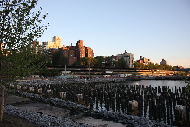
The BQE as seen from the Brooklyn Bridge Park. Photo via flickr user xbettyx.
A few weeks ago, I took a walk through Brownstone Brooklyn from Park Slope to the East River. I wanted to check out the new happenings at the Brooklyn Bridge Park, and after a stroll through the playground at Pier 6, I started to head toward Pier 1. Now, this week, a walking and biking path along the waterfront opened, but in early August before this path was ready, the best way to go from Pier 6 to Pier 1 was along Furman St., a little-used road underneath the double-decked BQE. Instead of tracking the cantilevered road way that serves as a barrier between Brooklyn and its picturesque waterfront, we opted for a leisurely stroll through Brooklyn Heights and along the Promenade instead.
Since Robert Moses first started tracing the contours of the Brooklyn-Queens Expressway and the connecting Gowanus Expressway, it was a controversial road. Built mostly above-ground, this elevated magnet for traffic jams tore through neighborhoods, and Moses famously refused to move the planned route one block west so it wouldn’t destroy a vibrant mixed-use community along 3rd Ave. in Brooklyn’s Sunset Park. Built without space for transit options, the BQE has cast a shadow on New York’s two most populous boroughs for decades.
Today, the BQE is a mess. It’s part of an important arterial road through that connects New Jersey, Staten Island, Brooklyn, Queens and the Bronx; provides access to key East River bridges; is well over capacity; and is living on borrowed time. While the road isn’t in danger of an imminent collapse, the physical structure is degrading quickly. Since the late 1990s, the city has toyed with the idea of righting the wrongs of the Moses Era and burying the parts of the BQE that shouldn’t be above ground.
A map of the proposed tunnel to replace the BQE. Click to enlarge.
In The Brooklyn Paper this week, reporter Stephen Brown explores one plan to tunnel the BQE underneath Brownstone Brooklyn, thus freeing up the two decks underneath the Brooklyn Heights Promenade for local traffic or other uses entirely. He writes:
State transportation officials are considering a tunnel under Brownstone Brooklyn that would stretch all the way from the Prospect Expressway to the Brooklyn Navy Yard, thereby bypassing all of Downtown and clearing the way for a major repair of the crumbling, sclerotic triple-cantilevered portion of the Brooklyn-Queens Expressway in Brooklyn Heights.
The extraordinarily ambitious two-and-a-half-mile tunnel is one of several options for replacing the beleaguered highway that is being considered by the state Department of Transportation, but it is already emerging as a favorite. “It’s brilliant,” said Allen Swerdlowe, an architect participating in state-sponsored design workshops, who praised the tunnel idea because it would discourage traffic-enraged drivers from exiting the highway as they do now and driving on local streets…
According to [Roy] Sloane [a Cobble Hill resident who proposed the idea], the tunnel could serve as an express route to North Brooklyn, while the triple-cantilevered stretch of the BQE would become a “local” route that would funnel traffic to the Brooklyn and Manhattan bridges as well as local streets.
Still, there were some differences among proponents of the tunnel as to what should be done with the decaying stretch of the BQE. “I don’t like that because it creates more capacity, and once you increase capacity drivers start using it and you create more problems,” said Swerdlowe, adding that he preferred a tunnel with exits to local streets and that the triple-cantilevered roadway could be converted into a recreation area of some sort.
In an ideal world, Swerdlowe’s dream would become a reality. A tunnel to replace the BQE would allow for adequate connections to local roads and the Brooklyn and Manhattan Bridges while the cantilevered roadway would be opened up to allow more direct access to the Brooklyn Bridge Park and waterfront. Furthermore, one goal of the road repair and replacement project should not be to encourage more driving in and around downtown Brooklyn.
For now, this tunnel remains a great idea on paper, but it’s a long way from reality. The Downtown Brooklyn BQE project is already 13 years in the making, and the New York State Department of Transportation doesn’t anticipate construction to start until 2017. By 2020, this road replacement, now budgeted for $254 million, will be complete. A tunnel through Brooklyn would cost significantly more than that and, if Boston’s Big Dig is any indication, take far longer than three years to complete. Still, the city needs to dream big, and by doing so, it can restore access to a part of the Brooklyn waterfront people, and not cars, should be enjoying.