As the Nostalgia Train continues to make its ride along the M line on Saturdays this month, the MTA unveiled its historic bus rides for the holidays this week as well. Every weekday from 10 a.m. to 2 p.m., the MTA will run its fleet of vintage buses along the M42 route. Everything, says Transit, is original except for the MetroCard farebox.
“These buses are a piece of New York City’s commuting past,” said Darryl Irick, head of MTA’s bus divisions. “I started my MTA career as a bus operator, driving these types of buses. As charming as they are, you cannot help but realize how far we have advanced when you ride one of our modern, low-floor buses.”
For transit buffs, a chance to ride these old buses comes but once a year. While the MTA rolls out its fleet for the bus fare during the September Atlantic Antic, only in December do these old vehicles run routes in Manhattan. Catch one now before they’re gone again.
In an otherwise mundane article on the state of bus speeds in the Bronx — spoiler alert: they’re slow — the Daily News let slip an interesting tidbit about upcoming plans for Select Bus Service. With an increase in the number of representatives from the Bronx now on the MTA board, the authority is under pressure to respond to subpar transit conditions in that borough, and as Daniel Beekman reported, the MTA and NYC DOT are exploring Select Bus Service for Webster Avenue’s Bx41.
Streetsblog started poking around DOT’s Select Bus Service website and found out that Utica Ave. in Brooklyn will get bus upgrades too. It was a big day for bus news. Yet, like every obviously smart bus route, DOT and the MTA will take the better part of half a decade to roll out some incremental service improvements. As Noah Kazis reported, these two routes have been under consideration since 2009, but the two agencies must still formulate plans and host public forums on the changes to traffic patterns and, of course, parking.
Ultimately, these two avenues need Select Bus Service, and one of them — Utica Ave. — could use a long-planned subway extension. Yet, we’re still going to see a tediously long process for these improvements. One day, the MTA will simply implement pre-boarding fare payment for its buses without a lengthy consultation with every single stakeholder at every single bus stop, and the buses will speed up. For now, we’ll just wait and wait and wait for another couple of Select Bus Service routes that might be ready before our next mayoral election heats up.
The M50 takes home the dubious distinction of being the slowest in the city.
If you’re trying to get across town in a hurry, you’re better off walking than taking the M50, according to the Straphangers Campaign. The transit riders advocacy group released its latest Pokey and Schleppy Awards this morning, and Manhattan’s M50 which runs crosstown on 49th and 50th Sts. was found to be the slowest with speeds of just 3.5 mph at noon on a weekday.
“You can push a lawnmower faster crosstown than it takes the M50 to go from 1st to 12th Avenue,” Straphangers attorney Gene Russianoff said at a press conference this morning.
It seems as well that riders are aware of the M50’s slow speeds. In 2010, the bus ranked 151st in ridership out of 191 local routes. Only 3905 riders per weekday board the slow-moving crosstown route. Anyone else heading east to west could hop the E or M trains via the 53rd St. tunnel or simply power themselves with their own two feet.
In addition to saluting the M50, the Straphangers also recognized the slowest routes in other boroughs as well. In Brooklyn, the B41 which travels via Flatbush Ave. between Kings Plaza and Downtown Brooklyn took home the prize. I’ve always believed Flatbush ripe for BRT-like improvements. In the Bronx, the Bx19 averaged 5.0 mph while the Q58 into Flushing was Queens’ slowest. The S48 earned recognition for its speeds along Staten Island but at an average of 8.8 mph, that’s one bus route that’s downright speedy.
In addition to honoring the city’s slowest buses, the Straphangers doled out the Schleppy award for the least reliable bus. Unfortunately, they couldn’t give the award to the entire bus network. So the M101/102/103 routes that run along Lexington and Third Avenues took home the joint prize. These buses — some of the busiest in the city — suffer from missed schedules and excessive bunching.
It wasn’t all bad news for buses though as the Straphangers declared that Select Bus Service was living up to its promises. They fond increases in travel speed of asmuch as 50 percent along both the Bx12 and M15 SBS corridors. It is promising then that two bus routes named least reliable in the city by the Straphangers — the B44 in Brooklyn and the S78 along Hylan Boulevard on Staten Island — will soon see their own Select Bus routes.
Of course, as I’ve noted recently, theses slow speeds and unreliable service levels are just one of the problems facing the buses. Ridership along local routes has been on a steady decline as the MTA has cut service levels over the past few years. Outside of the SBS routes, there is no indication that bus service will be getting better any time soon, and transit advocates seem to recognize that reality. “This year’s Pokey goes to yet another sad example of our underfunded transit system,” Paul Steely White, Executive Director of Transportation Alternatives, said. “The M50 might be slow but the bus system itself is racing toward catastrophe at full speed. New Yorkers deserve better.”
During yesterday’s Transit Committee meeting, the topic of conversation between the assembled MTA Board members and agency president Thomas Prendergast turned to bus ridership figures. As I’ve detailed here before, bus ridership is suffering from a slow, steady and long decline. As subway ridership nears record highs, the buses just aren’t drawing passengers.
Under fire from Charles Moedler and others, Prendergast reiterated the MTA line that the 2010 service cuts, in which numerous bus stops were eliminated and service was pared down across the board, were not the main drivers behind this decline in bus service. Rather, Prendergast said, the weak economy has stiffled discretionary trips and the MTA is recapturing many former bus riders through the subway system instead. After all, who wouldn’t rather have a ride faster and more reliable than a New York City bus?
As a contrast to this doom-and-gloom back-and-forth over the steady decline in bus ridership, city and MTA officials launched the latest Manhattan Select Bus Service route along the 34th St. corridor, and NYC DOT issued a progress report praising the M15 SBS. Regular old local bus service may be on the wane, but New Yorkers are flocking to the Select Bus Service routes, and the differences in service could provide an easy path to a better bus network throughout the city.
The story along 34th Street is a familiar one to us. After a rancorous debate amongst residents who did not want an ambitious Transitway in front of their lobbies, the city settled for a typical SBS route instead. Buses along the corridor will feature pre-board fare payment (with proof of receipt), dedicated and off-set bus lanes and camera enforcement of those lanes. Despite the reduction in plans with the death of the transitway, city officials are trumpeting SBS success stories anyway.
“Select Bus Service is proving to be a success wherever we install it,” said Mayor Bloomberg. “Travel times go down, ridership increases and safety improves with Select Bus Service. We expect to see the same positive results here on 34th Street and we will continue to look for more opportunities to expand this great service. We all know that when mass transit works well, more people use the service, which helps to free up our streets – a boost for our economy and our environment.”
At the 34th St. unveiling, DOT and the MTA also revealed a progress report on the SBS M15. So far, the new bus service is a success. Ridership along the SBS corridor from around 25,000 limited bus riders per day in 2010 to 35,000 SBS riders per day in 2011. Although some of that increase has come from riders shifting from the M15 local to the SBS routes, overall M15 bus ridership is still up by around 11 percent per day as overall bus ridership drops by 5-8 percent.
Meanwhile, travel times are dropping as well. An end-to-end run on the M15 Limited would take nearly 81 minutes. Forty of those were spent traveling while 19 were spent stopped at the bus stop, 18 at red lights and three minutes spent at other delays. The M15 Select Bus Service takes 68 minutes end-to-end. Of those, 35 are spent in motion and just 12 are spent at bus stops while the delays due to red lights remain the same. That drop — from 19 minutes to 12 at bus stops — is the key. By removing the line at the point of payment, the MTA doesn’t even need flashing buses to improve service.
So then can we see the key to better bus service in the stories of the SBS? By improving frequency along 1st and 2nd Avenues and speeding up the on-boarding process, the MTA has made bus service attractive, and it was rewarded with increased ridership. Elsewhere, buses run less frequently and involve long waits to board. Thus, ridership is down, and the MTA seems to know it. “If we are able to further reduce travel time through faster boarding and improved fare collection, we can expect an additional increase in ridership of five to ten percent,” Darryl Irick, the Senior Vice President at the Department of Buses, said.
If the authority is intent on improving bus convenience and combatting declining ridership, the answers are in Select Bus Service. Pre-board fare payment and regular and predictable service would go a long way toward improving the bus network. The buses simply must be treated as something more than second-class transportation. Otherwise, ridership will decline on every route but the glorified Select Bus Service.
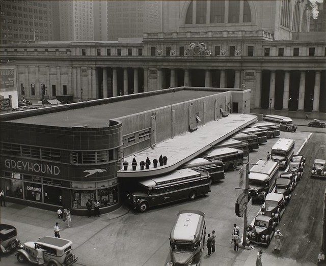
The Greyhound Bus Terminal on 33rd and 34th Streets between Seventh and Eighth Avenues shown here in 1936. (Photo via the New York Public Library)
Whenever New Yorkers grow nostalgic over Penn Station, it is by and large on aesthetic grounds. The current Penn Station is a far cry from a Great Public Building. There are no iconic images of light spilling into a grand hall. Rather, it is a dank, cramped, dirty and smelly station that doesn’t inspire kind feelings.
In addition to their looks, though, railroad stations serve functional roles as well. They need to have capacity to shuttle commuters into and out of the central business district of their host cites and should allow for intermodal connections as well. To a certain extent, both Penn Station and Grand Central realize that goal as New York’s two main rail depots offer easy connections to numerous subway lines. But what of the buses?
In an ideal world, bus terminals and rail stations would go hand-in-hand. In Boston and Washington, DC, for example, Greyhound delivers its riders to the main rail station. South Station serves as the terminus for Amtrak and the rides to Boston while DC’s Union Station features a Greyhound stop around back. In New York, the main bus depot at Port Authority is a subway ride away from the Amtrak stop at Penn Station and a subway ride away from Grand Central. It may offer up subway connections, but it leads to some convoluted rides.
It wasn’t always like this. In The Times this weekend, Christopher Gray delves into the history of a forgotten Greyhound depot that used to live where One Penn Plaza is now. In 1963, the terminal was torn down after Greyhound and Port Authority spent years fighting over the building. The PA wanted Greyhound to move to its then-new terminal at 42nd St. while Greyhound wanted to maintain its spot above Penn Station. Gray writes:
Greyhound was a consortium of different lines, including Pennsylvania Greyhound, half owned by the Pennsylvania Railroad. In 1935 the railroad cleared a through-block site just north of the station, from 33rd to 34th, for the new Pennsylvania Greyhound Bus Terminal….
In 1945, the Port Authority proposed its own single consolidated bus terminal, at Eighth Avenue and 40th Street, saying that intercity bus traffic jammed the streets. Part of the plan was a rooftop landing strip, 500 feet long, for what the authority called “the flying bus of the future.”
By this time the modernistic Greyhound terminal was not just a stop for travelers, but the haunt of vagrants, delinquents and petty criminals. In 1947 a police inspector called it the worst spot in Midtown. Five years later two escapees from the Matteawan State Hospital for the Criminally Insane waiting for a bus to Baltimore were caught by police officers with drawn guns. Nonetheless, Greyhound resisted the Port Authority plan. It liked its central location just fine, and had no need to help small operators gain the advantage of a union terminal. The city retaliated by prohibiting any bus terminal expansion in Midtown. The Port Authority completed its big, bland terminal in 1950, counting on Greyhound’s eventual capitulation — it was the biggest dog by far among the carriers.
The Port Authority’s bus terminal is located with direct access to the Lincoln Tunnel and out of the way of surface streets. Today, though, buses have made a resounding return to the Penn Station area as many of the discount offerings such as Bolt Bus provide pick-up service on the streets near 34th St. in order to avoid paying the PA’s gate fees.
As Gray notes, no one in New York expresses much nostalgia over the fate of the art moderne terminal. It didn’t spark debates over historic preservation as tearing down Penn Station did. But its place in history serves as a reminder of a time when, by design, ownership and economics, the city’s bus terminal offered up something more than a subway ride as a connection with the commuter and long-distance rail hub. It was a more sensible approach toward intermodal transit connections.
When the MTA released its subway satisfaction survey last week, it also published a similar one concerning the buses, and I didn’t pay it much attention. As with the subway survey, the bus examination used a similarly flawed scale and still found 70 percent of riders satisfied with local bus service. In one sense, that’s a shockingly high number considering how unreliable and slow local bus service can be.
This week, Allan Rosen at Sheepshead Bites drilled down on both the results of and the process behind the MTA’s bus service, and he too is less than impressed. As bus service varies wildly across routes and boroughs, Rosen, a former bus planner with the MTA, is critical of the sample size, the rankings and the way the survey ignores customer feedback on proper bus routing. His conclusion on the survey: “They first draw their conclusions, then pick and choose the data they want to show to back up those conclusions. In this case the MTA wanted to show that a majority of riders are content with the service they provide.”
That, in a nutshell, is why the bus surveys don’t tell us much. But there’s a bigger issue at work here: The bus surveys targeted only those who ride the bus. If the MTA wanted to find out why people aren’t satisfied with bus service, the agency needs to find people who don’t or no longer ride the bus and ask them why. In such a survey, one would find routing issues, speed (or lack thereof) and an unreliable schedule to be the prime disincentives and a clear reason why bus ridership is on the decline. That’s a survey worth doing.
Bus riders throughout the five boroughs will enjoy real-time bus tracking by early 2013.
While Londoners can now track their city’s buses, New York City isn’t too far behind. According to MTA documents released this week, if all goes according to plan, the MTA’s BusTime system, in use in Brooklyn and nearly ready on Staten Island, will be available city-wide by April of 2013. It could revolutionize the way New Yorkers use the bus system.
For the past few years, as surface travel has grown slower and bus service less frequent, the MTA has noted a marked decrease in bus ridership. According to numbers released this week by Transit, average weekday bus ridership in August was below 2.3 million for the first time in years. Although some of that decline was due to the total shutdown of the transit system in advance of Hurricane Irene, the bus system has not enjoyed an increase in ridership in years.
We could spend hours debating the reasons for the declining bus ridership. The vehicles are slow and uncomfortable. They don’t run on or close to the MTA’s posted schedules. Facing congestion and long boarding lines, crosstown trips in Manhattan, in particular, are often slower than walking. It’s no coincidence that as Select Bus Service improvements are rolled out across the city, bus ridership along those lines are among the highest around.
One of the key drivers behind the lack of faith in the city’s bus service concerns reliability. Although the authority posts schedules, buses come when they feel like it, often in bunches and rarely on time. Bus tracking projects, similar to the ones in place along 34th St. in Manhttan and the B63 route in Brooklyn, take the surprise out of bus travel and better allow riders to program their trips. If all goes according to plan, every bus will be equipped with such a tracking system by April of 2013, and riding the bus in New York City should become convenient again.
According to the presentation (found in the Capital Program Oversight Committee materials), the MTA is moving forward aggressively with plans to outfit the entire bus fleet with the tracking software. It will be activated in all 830 Staten Island buses by December of this year, and the project is coming in within the allocated budget. The city-wide rollout will begin next year.
Already, the project in Brooklyn, according to the MTA, is drawing high praise. The authority reports 1500 daily requests each day, and 94 percent of current users want to see it available through the city. I wonder what the other six percent want, but I digress. A “small percentage” of users find the text messaging function or website interface “difficult to use.”
For Staten Island, meanwhile, the project has been exceedingly simple to introduce. The authority awarded three contracts — one for on-bus hardware, one for back-office software and one for text message services — and installation began on the first of this month. Once the service is nearly ready, the MTA will begin a publicity blitz to prepare Staten Islanders for bus tracking.
Meanwhile, this project has an added benefit in that it will help drive forward the plan to replace MetroCards with a smart card tap-and-go payment system. The project was budgeted with $6.9 million from the New Fare Payment System initiative, and the $1.2 million in technology the MTA purchased for Staten Island’s bus tracking system will work with the new fare system as well. Furthermore, they’ve locked in software development through the city for $7.5 million, a total that includes development and six years of maintenance and hosting services. All in all, that’s not a bad deal.
As an information geek and transit advocate, I’m excited for the potential that BusTime should realize. If riders of any bus route can easily look up how far away the next bus is, they can better plan travel of all kinds. It should encourage people to use the buses as a way to supplement their subway rides, and it will take the sheer mystery out of riding the bus. Eliminating both the surprise of the schedule and the frustrating aspects of the wait should only increase customer satisfaction and use.
The buses have had a tough go of it lately, but things are starting to look up. Now if only we could bring a pre-boarding fare payment system to the entire bus network as well.
The U.S. Department of Transportation released nearly $1 billion in funds for localities to spend on various livable streets and bus facility upgrades this week, and New York City and the MTA secured over $134 million of that total for a variety of badly-needed projects. “These grant funds will make sure that bus service in our communities remains reliable and desirable while putting thousands of Americans to work at the same time,” Federal Transit Administrator Peter Rogoff said.
According to the grant list (available here as a PDF), the MTA will spend on the money on vehicle replacement and a bus command system while the NYC Department of Transportation will invest $3.4 million into a plan to improve bus access in and around the Broadway Junction area. The new command system, which will receive $34 million in federal funding, has been to designed to address communications failures that arose during last winters crippling blizzard.
Meanwhile, as the MTA’s bus fleet ages and buses break down more often, the authority will use over $60 million in federal funds to purchase 112 new vehicles. “This is welcome new funding and is a much needed investment that will go a long way toward updating our equipment and bus fleet,” authority spokesman Kevin Ortiz said to the Daily News. “It will help improve service and reliability for our customers.”
Bus riders in London are for a treat as Transport for London announced yesterday that its real-time bus tracking system is now available “anytime and anywhere.” With over 8000 buses running via 700 routes and making 19,500 stops in the U.K. Capital, the system is one of the most complex in the world, and the new system allows bus riders to check the locations of all buses within 30 minutes of a select stop, street or post code. The information is available via the web, mobile browsers and text message.
TfL officials also announced they will be replacing 2000 digital signs and adding 500 more in an effort to better inform riders at popular stations throughout the city. Later this year, the agency will release datasets so that mobile developers can release bus tracking apps. “Over six million bus journeys are made every day in London and this fantastic application of bus data will now enable people, wherever they are, whatever they are doing, to have at their fingertips the power to know exactly when their bus will reach any one of the Capital’s 19,500 bus stops they want to use, at any time of day or night,” Kulveer Ranger, Director of Digital London, said. “This technological step forward will revolutionise the way people use London’s buses and will banish the need for them to ever wait at a bus stop again.”
New York, meanwhile, is working its way toward a similar system. Transit teams are developing a bus-tracking platform for Staten Island that will be modeled after the B63 pilot. If all goes according to plan, Manhattan, Brooklyn, Queens and the Bronx will see a rollout over the next few years as the technology grows and funds are released. Our system won’t come with MTA-installed screens; rather, that’s a decision local merchants can make using the live streaming data. Still, it’s a worthwhile endeavor, and one, as London will show, that can truly change the way people view and use the bus system.
Over the past few years, the battle for street space has become a headline-grabber in New York City. On the one hand are folks who support vibrant street life. These folks argue for dedicated bus lanes, bike lanes and policies that promote pedestrian safety and mass transit over parking. On the other are those who believe that taking away a lane for driving or parked cars is an affront to liberty and freedom and that bike lanes are a part of the tenth circle of hell. Clearly, you know which side I’m on.
While the bike lane battles have been brewing in Park Slope and Williamsburg, the MTA and New York City DOT have been S-L-O-W-L-Y laying out plans for Brooklyn’s first Select Bus Service route. The new service will follow the path of the B44 along Nostrand and Rogers Avenues from Williamsburg to Sheepshead Bay, and throughout the planning process, it has received the usual array of windshield criticism. Community Board 15 voted it down due to its potential impact on parking while drivers complained that pedestrian-oriented improvements would take away space for their cars.
The MTA and DOT have been listening though, and now they’re making a case for their plan. Last week, they unveiled the latest iteration of the B44 SBS service, and while it still takes away some space for parking and auto lanes, businesses are rallying behind it because DOT has preserved capacity. In other words, by reallocating space from parked cars to vehicles in motion, the street will be more active. The latest presentation is available here as a PDF, and Streetsblog’s Noah Kazis offers up a thorough summary of the plans. He writes:
Nostrand Avenue SBS will, as in the Bronx and Manhattan, create dedicated bus lanes enforced by automated cameras and use high-capacity buses and off-board fare payment. With fewer stops, the bus will also spend more time in motion and less time starting and stopping. The Nostrand project will add another new feature: bus bulbs. By extending the sidewalk out to the street, bus bulbs mean that drivers don’t have to pull to the curb and back into the lane, resulting in a smoother and speedier ride. A raised curb means more level boarding onto the bus, advantageous for the elderly and the mobility-impaired. The extra space also means that the bus stop won’t crowd the sidewalk…
In order to preserve the same number of motor vehicle lanes during rush hour, where a bus lane is being installed DOT proposes turning the left parking lane into a through lane during the morning and evening peaks. This shouldn’t have too much of an impact on local merchants. At Nostrand and Empire Boulevard, only 14 percent of shoppers had driven to the area (and not all had parked on Nostrand). Further south, at Glenwood Road, only 13 percent of shoppers had arrived in a car.
Moreover, there’s a lot of room to add parking in other ways. On much of Nostrand and its cross streets, parking is currently free. The installation of meters will encourage drivers to move on once done shopping, freeing up space for others. The use of Muni-Meters will also allow more vehicles to park in the same area. Finally, loading zones and delivery windows will ensure that trucks have space at the curb rather than being forced to resort to double-parking.
This is transportation planning as it should be. In total, the amount of space constantly available for parked cars will dwindle, but what good are parked cars? They may provide transportation, but once idle, they sit lifeless in vibrant urban shopping areas. Muni meters will encourage turnover of parking spaces while buses, a major mode of transportation, will move more freely up and down the avenues. Cars won’t lose lanes, and businesses will gain loading zones. It’s a close to a win-win-win as one will find on the city streets these days.
Ultimately, though, this Select Bus Service suffers from the same problems that most of the MTA’s bus offerings do: While the route ends at the edge of the borough, most riders want to continue beyond that arbitrary border. The B44 SBS service would be far more useful if it crossed the Williamsburg Bridge and provided a direct connection with the M15 SBS as well as the F train at Delancey St. That’s a dream for another day though. Next fall, Brooklyn will finally get its first faster bus route.