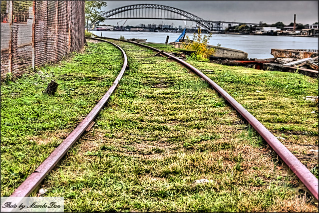
Archive for Staten Island
North Shore options include light rail, bus improvements
Posted by: | Comments
The MTA is consider light rail as a possible way to bring transit to Staten Island's North Shore. (Click to enlarge)
Could Staten Island be the home of New York City’s first true light rail line? Based on an analysis conducted by the MTA concerning ways to improve transportation along the borough’s North Shore, it very well might be.
The North Shore Alternatives Analysis, presented last week at Snug Harbor (and available here as a PDF), has been a long time coming. Nearly two years ago, the MTA announced a engineering study that would examine ways to reactivate transit along the old North Shore Rail Line right of way, and the agency started the Alternatives Analysis phase of the project in April 2010. New York’s Empire Development Corporation has called upon the MTA to reactivate the rail line, and now the MTA has whittled its options down to three.
The sexiest choice concerns a light rail network that would run from the Ferry Terminal to the West Shore Plaza. The 15-stop line is estimated to cost $581 million (in 2010 dollars) to construct and would improve travel times from St. George to West Shore Plaza by as much as 35 minutes. The MTA says that light rail would be ” more
compatible than heavy rail with potential plans for connecting services.” I optimistically take that to mean a connection across the Bayonne Bridge.
As far as the light rail details go, the Alternatives Analysis made a few assumptions. First, the Clifton Staten Island Railway shop could be modified to include light rail maintenance. Second, any work would have to include a new car wash, body shop and fueling station in Arlington.
The next option would involve tearing up any rail tracks, paving the right-of-way and turning it into an exclusive busway. By adding eight stops, this alternative could speed travel by as much as 33 minutes end-to-end, but it would carry a substantial price tag as well. The MTA estimates $352 million in capital costs, and for a only a busway, that seems excessive.
The third alternative is called the Transportation System Management. Similar to the required no-build option added to environmental impact statements, this alternative examines ways in which the MTA could improve service by essentially restructuring existing service but doing nothing else. For $37 million, TSM would improve travel times by a whopping 60 seconds.
So what happens next? The MTA is essentially trying to determine which of three alternatives will improve mobility while preserving and enhancing the North Shore’s environment, natural resources and open source and maximizing limited financial resources for the so-called greater public benefit. Over the next few months, the MTA will assess potential ridership figures, conduct traffic analysis for station sites and beging some conceptual engineering and cost refinements. It is, in essence, a pre-environmental impact review designed to identify the locally preferred alternative. They have already begun to solicit community feedback on this plan.
As a believer that no transit options are going to be faster than a dedicated rail line, I’d love to see the MTA pick light rail. It would provide a fast ride across Staten Island and the opportunity to connect into New Jersey. But of course, light rail would present its own set of challenges. New York City has no light rail infrastructure, and bringing it to Staten Island would require the MTA to build up from scratch a light rail support system. It’s not impossible, but for the current MTA, it’s ambitious.
Then there is the 800 pound gorilla in the room. I can see Staten Island becoming one of the MTA’s next great mega-projects, but it’s going to take some time. The $580 million (in today’s money) won’t materialize over night, and the MTA has to finish part of the Second Ave. Subway and the East Side Access project before funding another megaproject. Still, that a potential light rail line would cost something with millions at the end of it instead of billions could be its saving grace. Furthermore, New York City wants to redevelop Staten Island’s North Shore, and providing better transit is a key part of that plan. The dollars might somehow materialize.
So for now, there are rumblings of a plan. Nothing is concrete, but over the next few months and years, transit developments could come to Staten Island. It’s about time.
BRT Battlegrounds: Hylan Boulevard
Posted by: | Comments
From the MTA press office:
MTA New York City Transit and the New York City Department of Transportation invite the public to discuss transit service, traffic conditions and pedestrian safety on Staten Island’s Hylan Boulevard during an Open House that will be held on Wednesday, June 8, at The Renaissance Conference Center in the Grant City section of Staten Island beginning at 7 p.m.
The study will examine ways to improve safety, traffic flow and ease congestion along this major thoroughfare. The scope of the study will extend from the Staten Island Mall on Richmond Avenue to the 86th Street (R) subway station in Bay Ridge, Brooklyn. It carries several express bus routes and is served by the S78 and S79 with a combined average weekday bus ridership of more than 30,000.
The MTA and NYC DOT have already started to work on bringing Select Bus Service to Hylan Boulevard following its successful introduction in the Bronx (Bx12) and Manhattan (M15). In addition to concepts for Select Bus Service, the Hylan Boulevard Transportation study team will develop two or three different proposals for transportation improvements to be evaluated and discussed with the community.
The public is invited to learn more about the objectives of the study, examine display boards, and offer comments regarding transit, traffic and curb use on Hylan Boulevard with project team members. The event begins with a formal presentation at 7:15 p.m. but the general public may stop by any time between 7 p.m. and 8:30 p.m. at the Regency Room of The Renaissance at 2131 Hylan Boulevard (at Bedford Avenue) in Staten Island.
For more on the Hylan Boulevard proposal, check out NYC DOT’s project page.
So why does Hylan Boulevard matter? Well, lately, the MTA and DOT’s joint Select Bus Service efforts have not been met with arms wide open. The plan to turn 34th Street into a Transitway that would have benefited commuters, pedestrians and businesses alike was shot down by a small but stridently vocal group of NIMBYs. Hylan Boulevard, though, is the perfect place for a bus lane.
Staten Island is a tricky area for transit improvements. Because it has so long been disconnected from the subway map and enjoys some express bus service, it is by far the most car-dependent area of the city, and its residents are skeptical of anything that takes road space away from autos. Yet, this SBS proposal — which connects to the R train in Bay Ridge but should continue deeper into Brooklyn if not Manhattan — could be the first step in speeding up bus service and improving transit in and out of Staten Island.
I won’t be able to make the meeting tomorrow, but hopefully, Staten Islanders will take this chance to voice their support for better bus service and more transit options in an underserved borough.
At Tompkinsville, a low fare evasion total
Posted by: | CommentsSince 2008, the MTA had plans in the works to add tolls to the Tompkinsville stop along the Staten Island Rail Road. They move, they said, would generate $700,000 annually and cut into the SIR’s $3.4 million operating loss. That fare collection started in January, and it has so far been a guarded success.
In documents released this weekend, New York City Transit reported that ridership at Tompkinsville had totalled 204,000 paying customers between January 20 and the end of October with a low fare evasion rate of just 0.59 percent. Overall, SIR revenue is up only 6.1 percent over the same period last year, and the MTA attributes this lower-than-expected total to the weak economy and some higher labor expenses. The authority is still considering a plan to institute fares along the entire length of the SIR.
Building a subway to Staten Island with ARC dollars
Posted by: | Comments
Schematics of a 1912 plan to connect Staten Island with the BMT via a subway tunnel under the Narrows. Click to enlarge.
While New York City’s rail plans for Staten Island include just a modest proposal to reactivate the North Shore rail line and Mayor Bloomberg wants to spend the federal government’s $3 billion left over from the ARC Tunnel on a 7 line extension to Secaucus, one Staten Island politician would prefer to see the city deliver on a long-promised subway line to the island. State Senator Diane Savino (D-North Shore/Brooklyn) said this weekend that instead of pursuing a subway extension to New Jersey that “flies in the face of practicality and fairness,” the city should connect Staten Island to the rest of New York’s extensive subway system.
“If the Metropolitan Transportation Authority (MTA) wants to truly move people out of their cars and onto rail, extending a subway to the Island is the way to do it,” Savino said in an interview with SILive.com’s Judy Randall. “The MTA should complete a 1912 plan that would have rail and freight access from the terminus of Victory Boulevard to Brooklyn, along 67th Street, and then utilize the R train route along Fourth Avenue. The projected cost of the plan is $3 billion, the same as the extension of the 7 line under the Hudson River.”
The long-planned extension of the R train under Narrows wasn’t the only idea Savino put forward. “If a bi-state alternative is necessary in order to access federal funds, the city could extend the Hudson Bergen Light Rail from its present terminus at 8th Street in Bayonne over the Bayonne Bridge, making a ‘northwest passage’ to Manhattan via the PATH trains in Jersey City and Hoboken,” she said. “Keep in mind that 12,000 Islanders work in Hudson or Bergen County and 100,000 Islanders work in Manhattan every weekday.”
By my count, this is now the fourth public claim New York officials have staked to the ARC tunnel money. U.S. Senator Kirsten Gillibrand has called for the money to go toward MTA capital projects, and a group of House representatives echoed that call on Friday. Mayor Bloomberg of course is working on his 7 line program, and Savino wants to bring it home for Staten Island. Is her plan feasible?
In August, I explored the long and tortured history of a subway to Staten Island, and even then, I omitted the early years. Since the dawn of the 20th century, city planners had promised a subway to Staten Island from via the Narrows. Articles from 1901 and 1903 mention those plans, albeit in skeptical tones.
In 1919, the most ambitious expansion plans involved a tunnel under the Narrows as well as another to Lower Manhattan through the New York harbor. Had that Staten Island subway been realized, it would have traveled under Kill Van Kull and through New Jersey or via a direct line past Ellis and Bedlow Islands under the shallow part of the bay. Both routes would have connected to the IRT just north of South Ferry.
Today, the only feasible — and I use that word loosely — approach would seem to be via the Narrows to the BMT Fourth Ave. line. It’s five miles from South Ferry to the northern tip of Staten Island but just one mile under the Narrows. The line would branch off at around 59th St. where a short tunnel stub exists, but the trains would make the long, slow slog to Lower Manhattan via the 4th Ave. local and Montague St. tunnel. Such a trip would arguably be slower than taking the ferry, and without significant subway development in Staten Island, it wouldn’t provide comprehensive service at that end either.
Ultimately, it seems as though Savino’s subway plan is a wise one on paper that flies in the face of practicality. It would, however, make far more sense to Hudson Bergen Light Rail because it would draw riders from an underserved part of Staten Island. Only then with ARC money could dreams of better transit from Staten Island be realized a century in the making.
“In 1898, when the boroughs voted to consolidate,” Savino said this weekend, “Staten Island voted overwhelmingly to become part of New York City on the basis of two promises, a municipal ferry and subway service. After seven years we got ferry service, but 112 years later we are still waiting on the subway. Staten Island is part of New York City, with over half a million people. It is past time we have similar transportation alternatives that other boroughs have.”
NYCEDC urges reactivation of SI’s North Shore rail
Posted by: | CommentsFor the past few days, the idea of building out the 7 line to Secaucus has caught our collective imaginations. While that plan certainly has its appeal from a regional perspective, within the five boroughs, certain areas still suffer from subpar rail access though, and if it’s possible to improve access without spending billions on a cross-Hudson tunnel, the city should do so.
Prime for development is Staten Island’s North Shore. This underdeveloped area features a rail right of way that has had a mixed history. It opened to customers 120 years ago and served passengers for 63 years. From 1953-1989, the ROW serviced freight trains from New Jersey, but it shut for 16 years. Since 2005, the North Shore rail line has seen limited freight service, and the ROW has been problematic for community development to say the least. The rail line is in poor shape, and the ROW has cut off access to Staten Island’s waterfront.
Late last year, Staten Island pols and the MTA started making noises about reactivating the North Shore rail line, and early this year, the authority unveiled an alternatives analysis at an Open House. At the behest of and with money from Staten Island’s borough president, the authority delved into the island’s subpar mass transit. During the open house session, the authority presented various alternatives for improving transit along Staten Island’s North Shore. These plans included a light or heavy rail option for the ROW, turning the ROW into a dedicated BRT bus lane, improving local bus routes and expanding ferry and/or water taxi service. (For more on these options, check out the MTA’s NSAA planning page.)
Currently the MTA is working to turn the long list of potential projects into a short list before selecting a locally preferred alternative by mid-2011, but if the New York City Economic Development Corp. has its way, the locally preferred alternative will involve reactivating passenger rail service on the North Shore right-of-way. The NYCEDC has released preliminary results of a two-year study entitled North Shore 2030, and NY1′s Amanda Farinacci detailed, the study calls for rail service along the North Shore.
Unfortunately, the NYCEDC’s position is more nuanced that a flat-out call for rail service. They’ve identified what it would take to turn Staten Island’s North Shore into a more economically viable community and seem to believe that the rail line is in the way. At various points, the one-track route has a right-of-way of upwards of 100 feet, and the at- and below-grade areas block direct access to the waterfront, a vital part of the rehabilitation plan.
In its most recent presentation (PDF), the NYCEDC has urged the MTA to relocate the at-grade portions of the right-of-way. By doing so, waterfront businesses will see their land-use conflicts fade away, and the city will be able to improve the pedestrian and bicycle corridor along the shore. No cost estimates for the work have been released yet.
For now, the planning work will continue on this not-so-ambitious project. It should be a priority, but the MTA isn’t spending significant chunks of money on anything other than its current megaprojects. As this deal doesn’t have the same obvious real estate benefits as the Subway to Secaucus, the city won’t embrace it as readily as it has that crazy plan for the 7 train. Still, a direct rail line to the ferry terminal along Staten Island’s North Shore would serve as a prime impetus to development.
Perhaps then we should be thinking small and ensuring projects such as this are realized before we start sending the subway to far-off lands across the Hudson River. Perhaps we should ponder a subway tunnel to Staten Island instead of Secaucus. After all, it’s been nearly 100 years in the making.
A history of connecting the disconnected borough
Posted by: | Comments
Schematics of a 1912 plan to connect Staten Island with the BMT via a subway tunnel under the Narrows. Click to enlarge.
Staten Island is often called the forgotten borough by New York’s transit literati. With only some local and express bus routes connecting through to other boroughs and the Staten Island Railway as its only train line, the borough plays host to a high car ownership rate and is relatively disconnected from New York City Transit’s extensive four-borough subway network. For nearly 100 years, Staten Islanders have clamored for a subway connection to nearby Brooklyn or Lower Manhattan, and at every turn, the project has been shunted aside over costs or worse.
A 1912 article in The New York Times introduces us to a plan to build a subway to Staten Island under the Narrows. The piece focuses on how real estate values in Tompkinsville and Rosebank were on the rise amidst rumors of a direct subway connection to Manhattan’s Broadway line via a tunnel from Brooklyn that would parallel 67th St. in Kings County, and developers were excited about the future of Staten Island real estate. “In the first place, all Staten Island will not be greatly benefited because there is a large portion of the Borough of Richmond where there are no trolley lines connecting to with the future subway,” William E. Harmon said.
Harmon also mentioned the proposed terminus of this underwater subway route. “The end of the Staten Island subway is, according to present plans, to be at Arrietta Street, about five minutes’ walk from St. George’s Ferry,” he said. Today, Arrietta St. is better known as St. Marks Place, and the subway would spurred both south and north to make a connection with the Staten Island Railway.
Even though the Board of Estimates approved this subway connection to Staten Island on July 11, 1912 and the Mayor William Jay Gaynor followed suit on July 16, the subway was slow to materialize. A 1915 letter to the editor of The Times from Robert T. Cone highlights how borough activists were dying for a subway. Cone noted how travel took three times as long as it should have on the ferry and how Staten Island, if developed properly, could house 3 million taxpayers. He advocated for a two-track subway connection as well as a two-track freight connection from Staten Island to Manhattan. It was an ambitious plan indeed.
Four years later, the issue of a Staten Island subway connection again reared its head. Proponents of any subway plan had decided that a connection to Brooklyn via the 67th St. tunnel would be too indirect and the trip too long, and so they proposed a direct Manhattan-to-Staten Island tunnel. The Staten Island Subway Committee called for one of two routes: either a direct route to Battery Park via Ellis and Bedlow Islands under “the shallows of the bay of Robbins Reef and thence under Kill Van Kull” or by subway via Ellis Island to “within the bulkhead line below Communipaw [in Jersey City]; thence on an elevated structure just within the bulkhead line to a point near Robbins Reef; thence by subway under the Kill Van Kull.” The committee declined to include any cost estimates but assumed the net increase in tax assessments would eventually cover the price of this lengthy subway expansion.
In 1921, optimism was on the rise as the city promised residents of Richmond a subway expansion. For $25 million, the city would build a tunnel under the Narrows and connect Staten Island with the BMT routes in Bay Ridge. In present-day values, that $25 million would be approximately $297 million — or the equivalent of a few blocks of the Second Ave. Subway. At the time, the Board of Estimates had yet to determine if the subway to Staten Island would go under 67th St. or continue from the BMT’s terminal at 86th St.
In 1925, with the BMT in dire fiscal straits, the city’s engineers seemingly torpedoed the subway. That optimistic $25 million was far too low, they said. According to a survey, the real cost in 1925 would have been at least $40 million, and city engineers said they could build a bridge spanning the Narrows for $90 million. “But where a tunnel, if built, could be used only for rapid transit,” The Times said, “a bridge could carry not only vehicular traffic, on which tolls could be charged, but might be so constructed as to afford an outlet for freight cars.”
And thus died the subway to Staten Island. The plan for a bridge meanwhile laid dormant for decades. In the mid-1950s, Robert Moses revived the plan to span the Narrows, but much to the chagrin of The Times, writing in 1955, Moses declined to provide space for rail service on what would become the Verrazano-Narrows Bridge. When the bridge opened in 1965, the paper called it “more of an esthetic and engineering marvel than a way to get to Staten Island.” Without rail, it would become dominated by cars, and Staten Islanders were left waiting for that rail connection to the rest of the city. It’s 2010 now, and they’re still waiting.
For Staten Island, a few more years for the R44s
Posted by: | CommentsFor New York City Transit, a typical subway car has a lifespan of approximately 40 years. After those four decades are up, the agency prefers to replace old technology with newer cars that won’t require as much maintenance and feature cutting-edge transportation technologies. If that lifespan guideline were to be applied to the R44s currently in service along the Staten Island Railway, the MTA’s latest iteration of its 2010-2014 capital plan will call for rolling stock replacements, but it does not. Staten Island will be, according to Maura Yates, left with its R44s for at least another five years.
Although the R44s on the A line are going to be replaced, the news, however, is not all doom and gloom for those Staten Islanders looking for the MTA to focus on improving transit options on the island. Recently, the 63 R44 cars that make up the SIR fleet underwent an $11 million retrofit that should keep them running smoothly for a few more years, and the MTA is still planning to spend over $20 million to build the Arthur Kill Station.
Staten Island representatives to the MTA Board are satisfied with the investment and know the MTA will closely monitor the SIR’s aging rolling stock. “The irony is that our tracks, unlike our roads, are in better shape than the rest of the city,” Allen Cappelli said, “so our cars don’t take the kind of pounding that they do in other places. It was the recommendation that they did not need to put money in the budget to replace them. However, if a problem develops and we need to replace the cars, I’ve been assured we’ll buy the cars, but I’m not expecting that will have to happen.”
Transit to host SI North Shore rail planning open house
Posted by: | CommentsThe borough of Staten Island and the MTA, as I reported last October, are interested in reactivating the North Shore Rail line in order to bring more transit capacity to the underserved island. To further this project, New York City Transit is hosting a planning alternatives open house this evening. According to a press release from the agency, the Alternatives Analysis Study process begins with the identification of a list of alternatives that will then be narrowed through a series of detailed cost, impact and ridership analyses. This phase is expected to last 12-14 months, and the MTA will then issue a report recommending the locally-preferred alternatives for further development.
The open house tonight runs from 7:15 to 9 p.m. at the Snug Harbor Cultural Center and will allow the public to comment on the various alternatives as well as the goals and objectives of the project. The alternatives, says Transit, include “heavy rail, such as the SIR; light rail, such as Hudson-Bergen Light Rail; and Bus Rapid Transit service, among others.” At some point, as the economy approves and demand dictates, Transit will improve its Staten Island offerings, and this planning meeting is a positive first step.
Verrazano’s idle toll booths face the wrecking ball
Posted by: | Comments
MTA suits pose for a photo op in front of the long-defunct Brooklyn-bound toll booths on the Verrazano-Narrows Bridge. (Photo by Patrick Cashin, Metropolitan Transportation Authority)
In 1986, the United States Congress effectively eliminated two-way tolling on the Verrazano-Narrows Bridge, and since then, the toll booths on the Brooklyn-bound side of the bridge have sat empty and in the way.
Yesterday, though, a new day dawned for car-dependent Staten Islanders traveling across the Verrazano as the MTA kicked off a year-long $2.5-million toll-booth removal project that will help eliminate congestion and bottlenecks at the east-bound entrance to the bridge. “The removal of these toll booths is the most significant change in the physical design of the bridge since the lower level was opened to traffic in 1969,” James Ferrara, acting president of Bridges and Tunnels Acting, said.
The history of one-way tolling along the Verrazano-Narrows Bridge is an interesting one. In 1986, House representative Guy V. Molinari, a Republican from Staten Island, inserted a provision into the U.S. Department of Transportation’s appropriations bill that would have striped New York of one percent of its federal transportation aid if the toll booths were not eliminated. He did so, he said, because of increased pollution and traffic on the Staten Island side of the bridge. ”The last three or four months have been the worst we have ever seen, with traffic backed up across the island to the Jersey bridges,” Molinari said to The Times in early March 1986.
In exchange for eliminating the Brooklyn-bound tolling, the MTA hiked the cost of a bridge crossing by 100 percent. Instead of a $1.75 charge each way, the one-way toll would cost $3.50. The authority, after all, had to maintain what was then a Verrazano-Narrows Bridge surplus of over $250 million. Today, the one-way cash toll on the bridge is a cool $11.
The toll booths, though, have survived the years. In 1995, the National Highway System Designation Act permanently mandated one-way tolling, and Staten Island residents have long clamored for the destruction of the empy toll booths. Even though cars aren’t charged for crossing, drivers must still slow down to pass through the booths, and bottlenecks form as cars merge onto the bridge.
To address this problem, the MTA is going to eliminate the 11 toll booths on the Staten Island side of the bridge. When that work is complete, the authority will then realign the plaza roadway to allow for higher speeds leading onto the bridge. By 2014, the various on-ramps will be redesigned as well.
With 188,000 crossing in both directions each day, the Verrazano Bridge is the most heavily trafficked of the MTA’s bridges and tunnels. These renovations are a welcome change but do little to address the lack of transit integration from which Staten Island has long suffered. We can only hope that the MTA can be as forward thinking with the North Shore rail line as they are with the bridge. Hopefully, that project won’t take 25 years to get off the planning table as this toll-booth elimination proposal has.
On snowy days, MTA sees too many sick days
Posted by: | CommentsStaten Island bus drivers have a snow day problem, according to New York City Transit. Based upon data from a few snowy days this February, more divers are calling in sick on snowy days, the Daily News reports today. According to Transit, more drivers than usual called in sick on February 9, the day of a major storm in the New York City area, and by the time the snow had settled, 88 drivers out of Castleton – or 21 percent of that depot’s drivers – had filed for a sick day, and 15 percent of drivers from Staten Island’s Yukon depot had done the same.
To fill these service gaps, the MTA had to turn to workers who collect overtime, and the cash-strapped authority isn’t too pleased with the potential sick-day abuse. “Clearly there are cases where people are taking advantage of sick-day policies, and when and where we are able, we’re going to go after those cases in a very serious way,” Jeremy Soffin, MTA spokesman, said to Pete Donohue.
Vinnie Serapiglia, a vice president at Amalgamated Transit Workers Union Local 726, defended drivers who life outside of the city and could have faced “tough commutes” back to their suburban houses in Pennsylvania or New Jersey. “I don’t understand the thinking of the transit authority. The guys come here and put their all into the job,” he said, “and it seems like they are constantly under attack by management.”


