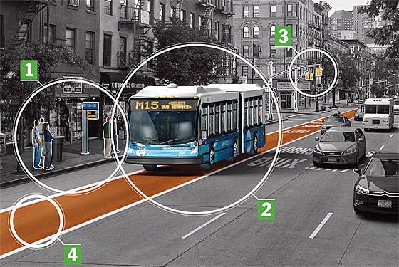
Until November, the MTA will be piloting a PayPass program, piloting a contactless fare payment method that involves using the chip inside most major credit cards to pay the fare. The authority is trying to move beyond a proprietary MetroCard system to something that allows for faster boarding and a more economically efficient fare collection effort. One benefit though — real-time tracking of bus locations — has flown below the radar.
The idea is, upon further reflection, both obvious and simple. The MTA will be collecting reams of instantaneous fare payment data as bus riders use their PayPass cards to swipe onto buses. (In fact, because the MTA has eschewed pre-boarding fare payment options for decades, they could collect this information now.) With the fare information comes the location and timing of the bus. If the bus knows it’s at, say, 104th St. and 5th Ave. and the fare processing system knows that people have just entered that bus, it’s possible to figure out how far away the bus is from any given point further on down the route.
According to Matthew Schuerman of WNYC, the MTA hopes to use that information to bring bus-tracking technology to its riders. While the MetroCard technology relies upon reading data off of a magnetic strip, the PayPass technology, says Schuerman, requires a modem and internet connection to function properly. He explains the authority’s plans:
Later this year, the MTA will begin taking the data from one of those routes and send it back to riders that request it, via text messages or the web browser on their cell phones. “If we are successful in implementing this program we will drastically reduce the cost and time needed to track our 6000-bus fleet,” MTA spokesman Kevin Ortiz said…
One drawback: the new approach will only tell riders where the bus is, in terms of distance or number of bus stops, but not when the bus will arrive. Ortiz says the MTA will open up its data so that software developers in the private sector can create smart phone apps.
“We will welcome the efforts of developers to help develop a robust prediction system that can deal with very difficult traffic and real world conditions associated with taking a bus throughout the city,” Ortiz said. “But right now we are not going to let the difficulty of making these predictions keep us from moving forward with what we can do now.”
The MTA, according to the report, views this as a cheaper alternative to the bus arrival boards currently in place at eight stops along 34th St. The MTA claims bringing that technology to bus shelters throughout the city could cost at least $140 million and would take a half a decade or more to roll out. Needless to say, the money isn’t there for such a project.
So the agency is looking for different solutions to a problem that has long since been solved around the globe. In a sense, the authority is taking Roadify’s bus-tracking approach and automating it with proprietary data. They’ll be doing the software development in conjunction with OpenPlans, the organization behind StreetsBlog that has been instrumental in pushing the MTA toward a policy of open information. It won the $265,000 contract to create a low-cost bus tracking solution.
Despite the promise of an upcoming pilot along one of the PayPass bus routes later this year, a few concerns circle the project. If the MTA is using credit card data to track buses, the authority will have to ensure that individuals’ privacy interests are protected. Furthermore, while this tracking program is low cost, it’s also low tech. OpenPlans will be making it available as a text message service with no mobile app component, and it will, as Schuerman noted, tell riders only how far away the bus is in terms of distance and not time. Still, for an agency known more for spinning its technological wheels than moving forward, this is a long-awaited step in the right direction.