In my write-up of Michael Kimmelman’s Times column on the Brooklyn-Queens streetcar route, I posed a question that would be answered by any study examining this proposal: What problem does this light rail/streetcar line solve? Intuitively, it seemed as though the biggest problems were at either ends of the line — Red Hook and Astoria — and the idea of an interconnected waterfront was otherwise a developer’s dream masquerading as a solution to something that isn’t actually a problem.
One of the bigger issues with The Times’ proposal is how the routing doesn’t connect to subways. While Alex Garvin’s original plan brought the streetcar through Downtown Brooklyn, Kimmelman swung west, away from badly needed subway connections and instead tightly hugging the waterfront. The Times scribe claims this will help serve areas that are “inaccessible” or served “barely” by the G train, referred to in the article as “the city’s sorriest little railroad.” It’s not clear how a low-capacity streetcar running at slower speeds will be better than even the much-maligned G train, but that’s besides the point for these so-called “desire lines.”
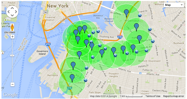
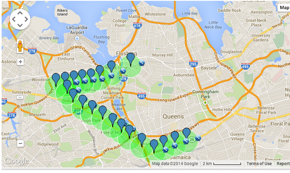
One of the biggest issues though with Kimmelman’s argument is that most of the Brooklyn-Queens waterfront isn’t really that far away from the nearest subway (let alone feeder bus routes). I did some radius mapping tonight of the waterfront and various other areas in Brooklyn and Queens, and the resulting images are instructive. I cannot unfortunately embed the map so you’re stuck with some images. Take a look at what happens when you chart areas that are more than half a mile away from the nearest subway.

In Brooklyn, Red Hook and Navy Yards are far from the subway.
In Queens, parts of Astoria are a trek away from the nearest subway stop.
If we’re truly concerned about getting people from transit deserts to jobs, then there are three discrete problems: The Navy Yards, an actual job center, isn’t close to transit while Red Hook, where low income housing dominates, is physically and psychologically isolated. Finally, in Astoria, parts of the waterfront are far from the N and Q trains, but there is an area where a ferry would make more sense as a lesser cost option.
The truth is the waterfront is not, by and large, without access to transit, and the G train, as scorned as it is, provides an adequate crosstown connection. A shorter streetcar route could help solve Red Hook’s problems and make the Navy Yards more attractive; a long streetcar that snakes past luxury developments that are a 10-minute walk from the nearest subway seems like more of a bonus for developers than a solution to a problem. But it’s still worth studying, objectively and thoroughly, and then when we have cost estimates and ridership projections, we can talk. As an object of desire though, it leaves much to be desired.
* * *
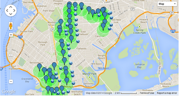
For fun (?), I have two more screenshots of the radius maps. Take a look at South Brooklyn and Eastern Queens. Forget desire lines and the developing waterfront; these are massive areas of the two most populous boroughs where the nearest subway connections are miles away. No one seems interested in solving that problem though.

Lots of highways but no subways for eastern Queens.

Forget about catching the train in South Brooklyn (or East New York for that matter).


 How about some bad news for 7 train riders on Friday evening? As part of the never-ending work to install a communications-based train control system on the Flushing Line, weekend shutdowns will resume at the end of February. Luckily for Mets fans — if Mets fans can ever be described as lucky — the work has been scheduled to coincide with away games. Any time the Mets are on the road, there’s no 7 service; any time they’re home, trains run with no problems.