Second Ave. Sagas
  • About
  • Contact Me
  • 2nd Ave. Subway History
  • Search
  • About
  • Contact Me
  • 2nd Ave. Subway History
  • Search
Second Ave. Sagas

News and Views on New York City Transportation

BrooklynView from Underground

Photo of the Day: Jay St – Metrotech

by Benjamin Kabak December 9, 2010
written by Benjamin Kabak on December 9, 2010

Where: On the platform at the station currently known as Jay St. – Borough Hall

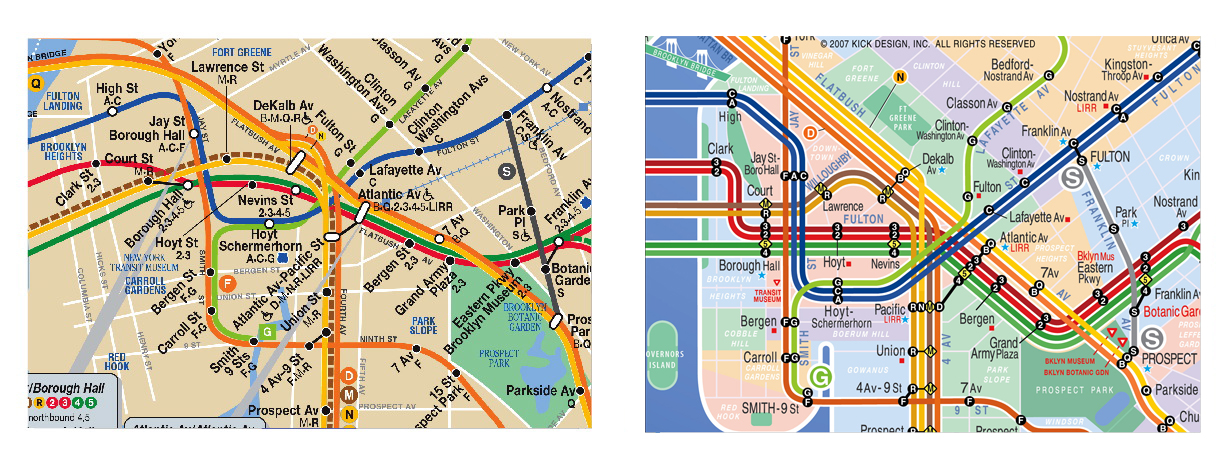
Via loyal SAS reader Jeffrey, who sent this photo in via his Twitter account, comes a snapshot of things to come in Downtown Brooklyn. As I reported over the weekend, the connection between the Jay St. – Borough Hall stop on the A/C/F and the Lawrence St.-MetroTech station on the R will open at 1 p.m. tomorrow, and the MTA wants everyone to know about the station’s new name. I’ll be at the ribbon-cutting in the morning, and I’ll try to take some photos of the new passageway. So far, all we’ve seen is a video. The changes should be reflected on the subway map in the upcoming weeks.

December 9, 2010 12 comments
0 FacebookTwitterPinterestEmail
Straphangers Campaign

Once more unto the Student MetroCard breach

by Benjamin Kabak December 9, 2010
written by Benjamin Kabak on December 9, 2010

The Straphangers Campaign does not think 2010 was a banner year for public transit in New York City. The rider advocacy group released their annual list of Top Tens today, and while they managed to put together a list of the top ten best stories of the year, their top ten worst are more sobering. The list includes fare hikes, service cuts and ever-increasing budget gaps, and it portends rough seas ahead for the MTA.

“There’s no way around it: 2010 was an awful year for subway and bus riders, filled with fare hikes, service cuts and a $900 million MTA deficit,” Gene Russianoff said. “But even in a rotten year, there are some things to celebrate, and, of course, to curse the fates.”

By and large, I don’t disagree with their lists. After all, fare hikes, service cuts and unfunded capital plans are bad news for everyone, and we all appreciate faster bus service, countdown clocks and real-time information available online. But where I think the Straphangers’ list misses the marks is, again, with Student MetroCards. They have proclaimed that saving student MetroCards is the number one best transit story of the year. Says their release:

1. Student MetroCards saved (June 2010). Subways and buses move 550,000 students for free or at half-fare. For months an MTA proposal to end student MetroCards was a serious threat that roiled the public. At one point, a Facebook page set up by two high school students to fight the proposal attracted 102,000 members.

The Straphangers had been influential in pushing to save the Student MetroCard program. They put out faulty math that overestimated the costs of paid transit by $300-$400 a year. They staged rallies. They held protests. They petitioned. But to me — a daily commuter with no children who saw Student MetroCard abuse run rampant in high school — one chart seals the deal:

This chart shows how MTA contributions to student transit have risen over the last 10 years while city contributions have stayed stagnant and state contributions decreased. I have never understood why the MTA should be expected to pay for student transit when the state and city aren’t doing their jobs.

Even when the Student MetroCards were “saved” earlier this year, the solution that emerged from the compromise was not an ideal one. The state simply restored the funding that it cut for 2009. Instead of promising to fund student travel, the state is contributing $45 million, the city is contributing $45 million, and the MTA is on the hook for well over $100 million. At a time when the service cuts package totaled less than what the MTA loses to student travel, I have to wonder why we’re making concessions to what amounts to a failure of government.

When the Student MetroCard program started in 1995, the MTA, city and state were to split the bill evenly with each side contributing $45 million. Unfortunately, the enabling compromise didn’t include adjustments for inflation, increased costs of providing the service or an explosion in the number of eligible. Perhaps, we should return to a scenario where the MTA contributes only $45 million as well, and if that total package of $135 million isn’t enough to provide free travel, then students will have to pay reduced-priced cards. The MTA is a transit agency, not a school bus, and the rest of us shouldn’t have to pay even more so students can ride for free.

December 9, 2010 12 comments
19 FacebookTwitterPinterestEmail
AsidesMetroCard

Automating the MetroCard replacement process

by Benjamin Kabak December 9, 2010
written by Benjamin Kabak on December 9, 2010

To replace a damaged MetroCard involves, as with many things at the MTA, a process. A rider has to get a form from a station agent, figure out how to fill it out and mail it back to the MTA in a postage-paid envelope. Over the course of a year, Transit processes 170,000 for demagnetized cards or for those scanned twice, and the average turnaround time is 7-11 days.

Lately, though, this cumbersome process has been slowed because the envelopes have become a scarce commodity. As the New York City Transit Riders Council President’s Forum a few weeks ago, a station agent spoke on how the postage-paid envelopes hadn’t been restocked in months, and Pete Donohue noted earlier this week that the envelopes were in short supply.

Today, the News reports that the MTA is going to use a nascent technology called the Internet to improve the MetroCard trade-in process. Beginning in the second quarter of 2011, when customers encounter a faulty card, they can fill out an online form to process an exchange. That move online should allow the MTA to cut down on administrative and mailing costs and should also speed up the exchange. The online upgrade, reportedly in the works since 2009, has been a long time coming, but what’s taken so long?

December 9, 2010 6 comments
0 FacebookTwitterPinterestEmail
View from Underground

What’s in a name, anyway?

by Benjamin Kabak December 9, 2010
written by Benjamin Kabak on December 9, 2010

The 59th St. Bridge isn't feelin' too groovy these days. (Photo by flickr user wallyg)

Immortalized in song by Simon and Garfunkel in the mid-1960s, the 59th St. Bridge will soon have a new name. As part of an effort to honor former New York politicos, the Bloomberg Administration announced yesterday that the Queensboro Bridge will be renamed for Ed Koch and the Brooklyn-Battery Tunnel for Hugh Carey. So now if there’s too much traffic on the RFK, you can jet down the Koch to get to Queens.

The former mayor was quick to embrace the honor that sees a 101-year-old bridge deprived of its rightful name. “It’s a workhorse bridge,” Koch said of the landmark. “And that’s what I am, I’m a workhorse. Always have been. I feel very compatible with it.”

Koch also praised former Governor Carey as well. “I’ve been trying to get something named for Governor Carey,” he said. “I think he was the best governor of the modern era and saved both the city and the state from default and from bankruptcy.

The current mayor was equally as magnanimous as the old. In a statement issued yesterday, he said that the Queesnboro Bridge, like Koch, is “icon of the city that’s been bringing people together for a long time.” It was a day for humility it seems.

Over the past few years, the state legislature has gone on a naming binge. We have the Joe DiMaggio Highway, the Robert F. Kennedy Bridge, the Ed Koch Bridge, the Hugh Carey Tunnel and the Jackie Robinson Parkway. Unfortunately, as famous names are appended to iconic and familiar roads, the names lose all meaning. It’s much easier to figure out where the West Side Highway, Triborough Bridge, Queensboro Bridge, Brooklyn-Battery Tunnel and Interboro Parkway are than it is to give directions to these location-less named parts of town.

For city too, these changes aren’t free. At a time when municipal dollars are stretched thin, New York is going to have to come up with money for new signs. It cost the city $4 million to rebrand the RFK Bridge, and everyone stills just calls it the Triborogh Bridge. This time, the city is going to look for private donations to cover the costs. Perhaps Mr. Koch can fund his own bridge.

While the City Council seemed enthusiastic about the new names — “Over 40 years ago, the Queensboro Bridge had Simon and Garfunkel feelin’ groovy and today there is no one in our city groovier than Ed Koch,” Christine Quinn said — not everyone shared the joy. “To glibly rename things is very sad,” Bob Singleton, a Queensboro Bridge historian, said.

But tongue-in-cheek sarcasm aside, watching the state simply give away the names to these iconic structures raises some questions. Just a few days ago, the Wall Street Journal pondered the role naming rights will play as cities look to close budget gaps. Public schools and parks may soon carry corporate names while transit systems in Philadelphia, New York and Chicago have begun to auction of the names of subway stations.

While it’s undeniable that naming rights can lead to dollars, many across the country have not been keen to embrace the intrusion of the corporate into the realm of the public. Do we sacrifice convenience and usability for the sake of money? In New York, we’re sacrificing instant name-and-place recognition for the sake of honoring historical figures, most of whom aren’t alive to appreciate the honor.

Maybe, then, naming rights aren’t the way to go without stringent guidelines. I’ve long believed that subway stations can append corporate names but shouldn’t replace geographical identifiers with place-less sponsorships. If Disney wants to buy the Times Square station’s naming rights, it shouldn’t be called Walt Disney Station; rather, it should be called Disney-Times Square. People need to know where they’re going.

But it’s too much to ask of our state legislature to keep convenience in mind. New Yorkers will still give directions to the Battery Tunnel and the Queensboro Bridge because those are the landmarks we know and that’s where the roads lead. When someone asks “How you doin’?” the answer shouldn’t be “lost trying to find my way to the Ed Koch Bridge.”

December 9, 2010 34 comments
0 FacebookTwitterPinterestEmail
View from Underground

Photo of the Day: Pay phone as trash can

by Benjamin Kabak December 8, 2010
written by Benjamin Kabak on December 8, 2010

When: Wednesday, December 8, 2010 at around 1:30 p.m.
Where: The back end of the Manhattan-bound platform at the 7th Ave. stop along the Brighton Line

This sad, neglected — and broken — pay phone has become a de facto trash receptacle. Someone, perhaps angry that they missed the train or annoyed with the caller on the other end of the line, smashed the earpiece off the headset, and the phone now dangles to the side. On top of the now-useless pay phone is an empty coffee cup, discarded earlier in the day because there are no nearby garbage cans. The pay phone is bound to remain broken for longer than the coffee cup will stay there, but at least the broken relic of another era had its morning joe.

December 8, 2010 5 comments
0 FacebookTwitterPinterestEmail
AsidesSecond Avenue Subway

A hearing for 2nd Ave. businesses, but what response?

by Benjamin Kabak December 8, 2010
written by Benjamin Kabak on December 8, 2010

Since construction fences, noise and debris descended upon Second Ave. in mid-2007, businesses along the future subway route have struggled to survive. Fewer Upper East Siders are walking the work-clogged strip and restaurants who have had to sacrifice their outdoor cafes due to lost sidewalk space have seen revenues drop precipitously. Business owners have routinely asked for state or MTA hand-outs, but these requests have been met with a resounding no.

Last week, the Second Ave. Business Association again went hat-in-hand to the New York Senate, Dan Rivoli reported in Our Town. During a hearing on the status of the Second Ave. Subway construction, Joe Pecora asked for two intertwined things: “Promote foot traffic that has gone down 50 percent. Make Second Avenue a sales tax-free zone.” In the past, the Senate had failed to act on a grant fund or a property tax abatement, and the city has not responded to these requests either.

For its part, the MTA vowed again to make sure its work site is cleaned up. The authority will ensure that garbage isn’t left to rot — and breed rats — overnight, and capital construction has engaged in an effort to beautify the construction area. They are considering a call to minimize the number of empty construction containers left in front of storefronts as well. Yet, from politicians and from the MTA the message was the same: There’s only so much they can do, and the business disruptions are just the cost of constructing a subway line that will lead to a neighborhood boom when it’s completed. “Our options,” City Councilman Dan Garodnick said, “are limited.”

December 8, 2010 1 comment
0 FacebookTwitterPinterestEmail
Subway Maps

Debating subway map form and function

by Benjamin Kabak December 8, 2010
written by Benjamin Kabak on December 8, 2010

Massimo Vignelli's diagrammatic map still inspires discussion nearly forty years after its debut.

After listening to the current iteration of the New York City subway map called everything from bilious to muddy to messy to a mongrel, I almost felt bad for the thing. Almost. It’s been insulted, beaten, torn apart and called everything under the sun, but it still looks ugly.

Last night, the Museum of the City of New York hosted an All Star panel of subway map men. Massimo Vignelli, John Tauaranc, Eddie Jabbour of KickMap fame and historian Paul Shaw took turns exploring the evolution of the form and functionality of the New York City subway map. The MTA’s map folks were invited but apparently declined the invitation. While the various designers disagreed on the proper appearance for a map, the one thing that united the evening was an obvious disgust with the current iteration. “Clarity is the key,” Tauranac, one of the designers of the 1979 subway map, said. “The MTA simply does not do that.”

The design shortcomings of the current map are evident in Lower Manhattan where station names overlap subway route lines and information isn't easy to comprehend.

The venerable Vingelli took the floor first. While the angular subway schematic that divided the city’s subway riders remains Vingelli’s most iconic New York piece, the subways are replete with the 79-year-old Italian designer’s imprint. The relatively clear signage and the unified use of Helvetica was a part of Vingelli’s Graphics Standard manual that the TA adopted in the late 1960s.

To introduce his idea for a subway map, Vingelli spoke about merging form and function. The two aren’t mutually exclusive, and in fact, a good designer will figure out a way to incorporate both. A map, he said, is a geographical representation of an area designed to get around at street level. A subway map should be a diagram used to show how routes interact with each other. “When you try to mix the two things, you’re just making a mongrel,” he said of the current subway map.

Vingelli, who understands the impact his map had on form and function in the public realm, didn’t set out to design something for MoMA. “Designing a diagram is not just a piece of art,” he said. “It’s really a logical thing.”

His original plans included three different schematics for subway stations. His diagramatic map would hang next to a geographic map of New York City and a neighborhood map. “From the beginning, we knew one map could not do the job,” he said.

Today, MTA stations feature neighborhood maps — decades after they were first proposed — but the authority decided to merge the geographic map of the city with the subway map. Vingelli did not approve. Showing high-res images of the subway, he detailed the typographic problems with the map and its cartographic shortcomings. The current map, he noted, features call-out balloons and haphazard text. “It covers the information it’s supposed to provide,” he said.

Ultimately, Vingelli, who seems not bitter but upset that the MTA discarded his map, blamed the authority for meddling with the map to the point of incomprehension. “You don’t need a good designer,” he said. “You need a good client.”

The 1979 iteration begat complexity on a map.

Following Vignelli, Tauranac took the mic. He was a member of the MTA’s map committee in the late 1970s and helped lead the effort to replace the Vignelli map with something more “quasi-geographic.” But he said, “over the years, it has become more quasi and less geographic.”

Unlike Vignelli’s map, Tauranac’s representation of the subway map attempts to provide geographic context. The key change between Tauranac’s and Vingelli’s map involved a consolidation. While Vingelli used different lines for each subway route, Tauranac’s committee with help from the design team led by Michael Hertz used trunk lines instead to remove clutter. But the MTA has added more and more extraneous info, and it’s too hard to see the important stuff.

Today, Tauranac offers up his own map for sale. It’s a semi-schematic, semi-geographic meld that features type face that doesn’t run at angles or cover subway lines and shows the difference between night, day and weekend service. It is a far cry from the current iteration of the official map, and Tauaranc’s disgust with The Map showed. “Land got a color I can only describe as bilious, and Just ask any 5th grader what color a park is.” he said of the latest MTA map refresh. “The MTA map has deteriorated. It’s messy in form and less valuable in function.”

For Tauranac and for Kickmap’s Eddie Jabbour, the current MTA version isn’t informative enough in the right ways. Tauaranc spoke at length about the service guide, once a key feature of the Vingelli map and now relegated to the Internet. Without it, the map is only half useful. “When does the Q go to Astoria?” he asked. “Rush hour? Weekdays? Weeknights only? Weekends only? And when does it stop at 49th Street?” With the current map, you just can’t tell.

Eddie Jabbour's KickMap simplifies the tangle of subway crossings in Brooklyn. (Click to enlarge)

The KickMap, which first came to my attention back in 2007 and is now available in app form for iPhones, tries to solve those problems. Jabbour’s map borrows elements of Vingelli’s map and tries to produce an easy-to-follow schematic with geographical underpinnings. The mobile version will automatically show nighttime service after 11 p.m., and it is, says its creator, more user-friendly. “There’s a cynicism in that map,” Jabbour said of our subway map. “It’s almost as though someone said, ‘That’s where Atlantic/Pacific is going to go. Tough. Figure it out.'”

As the speakers wrapped up their presentations, the lesson from the evening was one of visual simplicity and information presentation. The Map with its intermodal balloon boxes despised by all has tried to do too much with too little, and the MTA seems content to let the quasiness win out over visual simplicity or a form that serves a function. “Our map is a mongrel,” Jabbour said. “It’s an actually barrier to understand the system.”

December 8, 2010 48 comments
0 FacebookTwitterPinterestEmail
Subway Maps

Event of the Day: A talk on the subway map

by Benjamin Kabak December 7, 2010
written by Benjamin Kabak on December 7, 2010

Massimo Vignelli will discuss his iconic and controversial subway map tonight at the Museum of the City of New York.

I’ve got a soft spot for subway maps. The history of the subway map traces the history of the city, and as with everything else in New York, we’ve seen controversy emerge out of the map as well. Should the subway map be geographical? Schematic? A work of it? The debate is endless.

Tonight, at 6:30 p.m. at the Museum of the City of New York, various cartographers will gather for a talk entitled “The New York City Subway Map: Form v. Function.” The museum’s website describes it as such:

Massimo Vignelli’s 1972 New York City subway map, produced by the Metropolitan Transportation Authority, was considered a design triumph—earning itself a place in the collection of the Museum of Modern Art—but it was also criticized as confusing to passengers. A new version of the subway map was released earlier this year, re-raising the enduring dilemma of how best to achieve both functionality and beauty. Join the creators of several subway maps, including John Tauranac and Massimo Vignelli, for a discussion about designing for the riding public, featuring Eddie Jabbour, creator of Kick Map and the NYC subway app; and Paul Shaw, author of Helvetica and the New York City Subway System: The True (Maybe) Story.

I’m looking forward to this one, and if you’ve got a few hours free tonight, check it out. The Museum of the City of New York is located at 1220 Fifth Avenue between E. 103rd and E. 104th Sts., a short walk from the 6 train stop at 103rd St.

December 7, 2010 7 comments
0 FacebookTwitterPinterestEmail
BusesStraphangers Campaign

The M42’s slow trek across town

by Benjamin Kabak December 7, 2010
written by Benjamin Kabak on December 7, 2010

Transportation Alternatives' Paul Steely White unveils the Schleppie Award while Gene Russianoff looks on. (Photo courtesy of Kim Martineau/Transportation Alternatives)

If you’re trying to get across 42nd St. in a hurry and the M42 is on the horizon, you’re better off walking. At least that’s the message the Straphangers Campaign and Transportation Alternatives had for the city’s transit riders as they unveiled the annual Pokey and Schleppie Awards for the New York’s bus routes today.

Maintaining an average rate of just 3.6 miles per hour during the noontime run, the M42 captured the Pokey Award, the Straphangers’ recognition for the system’s slowest bus. It is the second consecutive year this midtown route has taken home the trophy. For anyone young enough and healthy enough, it is indeed possible to cross Manhattan on foot faster than the M42 covers it on wheels.

The Straphangers and TA also unveiled the slowest routes in the other four boroughs as well. Taking home the honors were the B35, the Bx19, the Q58 and S42. Still, none of those buses can hold a candle to the M42. Each maintains speeds above 5 mph, and the S42’s 8.2 mph velocity might be slow for Staten Island but would be considered speedy along the streets of Manhattan.

As for the Schleppie, a nod for the system’s “least reliable” bus, the Bx41, the system’s 15th most popular bus route, took home the award. The Straphangers had more on the unreliable local buses:

Almost one in four Bx41 buses — 23.5% — arrived bunched together or came with big gaps in service during the first half of 2010. Last year’s “winner” with the worst reliability was the B44, which runs between Williamsburg and Sheepshead Bay, Brooklyn.

The groups noted, however, that the number of unreliable buses had more than doubled in the past year. MTA New York City Transit measures a “borough-representative sample of 42 high-volume bus routes” for unreliability. In the first half of 2009, the groups found four routes out of those 42 had more than one in five buses arriving off schedule. However, that has grown to 11 routes in the first half of 2010.

The most unreliable bus routes in each of four boroughs with over 20% of buses bunched together or big gaps in service are:

  • B44: 21.7% unreliable btw Sheepshead Bay and Williamsburg on Nostrand Avenue
  • Bx41: 23.5% unreliable btw Wakefield and The Hub on White Plains Rd/Webster Ave
  • M101/2/3: 22.3% unreliable btw Upper and Lower Manhattan on 3rd and Lexington Avenues
  • S78: 21.8% unreliable btw St. George Ferry and Tottenville on Hylan Boulevard

While local buses remain among the worst forms of surface transportation in the city, TA and the Straphangers acknowledged the MTA’s Select Bus Service plan. It’s taken a painfully long time to get Select Bus routes off the ground, but riders are noticing improvements.

“The next generation of buses is making inroads in New York City — Select Bus Service can cut travel time for riders,” Paul Steely White, executive director of Transportation Alternatives, said. “Where these fast buses have been tried in the Bronx, travel times dropped at least 20 percent. Similar improvements were recently installed on Manhattan’s East Side. Rather than pokey and schleppie buses, New Yorkers deserve quick and efficient bus service. We are encouraged by the city’s willingness to make New York’s buses work better.”

Eventually, as the MTA replaces the MetroCard with a contactless payment technology, bus load times will improve, and bus speeds should improve. Still, though, bus stops are much too close together, and the lack of lane and signal priority means that buses will forever be at the whims of surface conditions. Until bus routes are cleared, pokey and schleppy will be a perfectly adequate description of New York City bus service.

For more on the awards and the Straphanger’s methodology, check out their press release. After the jump, a vide on the awards from Streetsfilms.

Continue Reading
December 7, 2010 12 comments
0 FacebookTwitterPinterestEmail
AsidesFulton Street

Fulton St. Hub finally sticking to a schedule

by Benjamin Kabak December 7, 2010
written by Benjamin Kabak on December 7, 2010

In Transit Fantasyland, the Fulton St. Hub would have been completed last year at a cost of $700 million. Instead, after years of delays, redesigns and cost overruns, the MTA in 2007 eventually set a completion date of 2014 and a budget of $1.4 billion. “What I present today, I stand by. I expect you to hold me accountable to it,” Capital Construction President Michael Horodniceanu said a few years ago, and it appears as though the authority is indeed sticking to its schedule.

As Matt Dunning of The Tribeca Trib reports, the Fulton St. Hub is still on pace for a 2014 opening. “The job is going well,” Uday Durg, a program executive at the MTA, said to a Community Board 1 meeting recently. “All of our contracts are moving on schedule and are tracking on budget.”

As Dunning notes, 2011 will see the continued gradual opening of parts of the hub. Southbound R trains will again pick up and drop off passengers at Cortlandt St. by 9/11/11, the tenth anniversary of the 2011 attacks. A new entrance for the West Side IRT will open on William St., and a temporary tunnel between the IND platform and the East Side IRT stop will be available for use as well. With the Corbin Building shored up and funding in place, the plagued project is finally getting well off the ground.

December 7, 2010 6 comments
0 FacebookTwitterPinterestEmail
Load More Posts

About The Author

Name: Benjamin Kabak
E-mail: Contact Me

Become a Patron!
Follow @2AvSagas

Upcoming Events
TBD

RSS? Yes, Please: SAS' RSS Feed
SAS In Your Inbox: Subscribe to SAS by E-mail

Instagram


Disclaimer: Subway Map © Metropolitan Transportation Authority. Used with permission. MTA is not associated with nor does it endorse this website or its content.

Categories

  • 14th Street Busway (1)
  • 7 Line Extension (118)
  • Abandoned Stations (31)
  • ARC Tunnel (52)
  • Arts for Transit (19)
  • Asides (1,244)
  • Bronx (13)
  • Brooklyn (126)
  • Brooklyn-Queens Connector (13)
  • Buses (291)
  • Capital Program 2010-2014 (27)
  • Capital Program 2015-2019 (56)
  • Capital Program 2020-2024 (3)
  • Congestion Fee (71)
  • East Side Access Project (37)
  • F Express Plan (22)
  • Fare Hikes (173)
  • Fulton Street (57)
  • Gateway Tunnel (29)
  • High-Speed Rail (9)
  • Hudson Yards (18)
  • Interborough Express (1)
  • International Subways (26)
  • L Train Shutdown (20)
  • LIRR (65)
  • Manhattan (73)
  • Metro-North (99)
  • MetroCard (124)
  • Moynihan Station (16)
  • MTA (98)
  • MTA Absurdity (233)
  • MTA Bridges and Tunnels (27)
  • MTA Construction (128)
  • MTA Economics (522)
    • Doomsday Budget (74)
    • Ravitch Commission (23)
  • MTA Politics (330)
  • MTA Technology (195)
  • New Jersey Transit (53)
  • New York City Transit (220)
  • OMNY (3)
  • PANYNJ (113)
  • Paratransit (10)
  • Penn Station (18)
  • Penn Station Access (10)
  • Podcast (30)
  • Public Transit Policy (164)
  • Queens (129)
  • Rider Report Cards (31)
  • Rolling Stock (40)
  • Second Avenue Subway (262)
  • Self Promotion (77)
  • Service Advisories (612)
  • Service Cuts (118)
  • Sponsored Post (1)
  • Staten Island (52)
  • Straphangers Campaign (40)
  • Subway Advertising (45)
  • Subway Cell Service (34)
  • Subway History (81)
  • Subway Maps (83)
  • Subway Movies (14)
  • Subway Romance (13)
  • Subway Security (104)
  • Superstorm Sandy (35)
  • Taxis (43)
  • Transit Labor (151)
    • ATU (4)
    • TWU (100)
    • UTU (8)
  • Triboro RX (4)
  • U.S. Transit Systems (53)
    • BART (1)
    • Capital Metro (1)
    • CTA (7)
    • MBTA (11)
    • SEPTA (5)
    • WMATA (28)
  • View from Underground (447)

Archives

Meta

  • Log in
  • Entries feed
  • Comments feed
  • WordPress.org
  • Facebook
  • Twitter
  • Instagram

@2019 - All Right Reserved.


Back To Top