
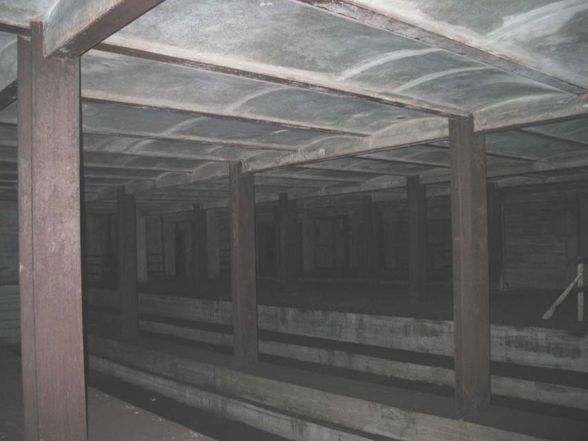
A six-track ghost station sits above the G train stop at Broadway in South Williamsburg. (Photo via Subway & Rail)
When news of the Underbelly Project’s subway station art show hit the Internet this weekend, subway lovers scrambled to adduce the site and quickly settled upon the South 4th Street subway shell. This is a six-track, IND station in South Williamsburg hidden from the public but identical to the station seen in the photos presented to the public by the Underbelly Project. To the uninitiated, this stop may sound like a phantom subway station. Isn’t the only 4th Street station at West 4th in Manhattan? What is this South 4th Street station? Where is it? And where do the trains that once serviced it go?
The answers — especially to the last question — are tricky. The South 4th Street subway station isn’t anything quite like the city’s other abandoned stations. It’s never seen revenue service before, and in fact, it doesn’t even have a rail track running through it. It exists in fragments — poured concrete, unfinished stairwells, no lighting, no through tunnels — and is a remnant of an era of larger plans. In a sense, it’s not an abandoned station because no trains ever served it nor could they. Rather, it is an abandoned dream.
The South 4th Street was to be a major transfer and connection point for the IND Second System. The shell was built into the ceiling of the Broadway stop on the IND Crosstown — a so-called provision statement — before the city even knew if funding for the remainder of the line would ever materialize. When World War II and the subsequent advent of the automobile age put a grinding halt to subway expansion, the South 4th Street shell remained just that. It is a testament to another era, behind false walls and closed-off staircases, and today, it apparently housings one of the largest street art exhibitions in New York City.
Today, a six-track station seems unimaginably wasteful. The MTA is building the Second Ave. Subway with only two tracks due to budgetary constraints, and the only other stations and tunnels with six tracks — Hoyt-Schermerhorn comes to mind — never make use of the full array of options. The two outer tracks at Hoyt-Schermerhorn lead into the Court St. stop which we know today as the Transit Museum. It too was part of the grandeur of the Second System and a planned Brooklyn extension for the 1930s edition of the Second Ave. Subway.
But back in 1929 and again in 1939 when the city was trying to build up its subway system, South 4th Street in South Williamsburg was to be a major intersection. The plans are aggressive: Both the Sixth Ave. and Eighth Ave. lines would have passed through this station, bound for multiple points east, south and north. The Second System, which I explored in depth in 2008, which have reimagined New York City, and the Second System’s Big Apple would be a more accessible one than ours is today.

According to proposals from the era, the city considered a variety of routes into Brooklyn and Queens, but the Manhattan connections were the same. The Sixth Ave. local would have run the route we know today, but from Second Ave., the trains would have continued east. In fact, the stub tunnels on the two middle tracks that extend eastward past the Second Ave. stop are a provision for the route that would have led through South 6th St. The other part would have swung the Eighth Ave. local up Worth St., past the current Essex St. East Broadway stop, across the East River and to South 4th Street.
Eastward out of South 4th Street, the possibilities were twofold. In the 1929 plan, one set of tracks would have led down Stuyvesant Ave., crossing the IND Fulton St. Line at Utica Ave. — where another shell station and some unused mezzanines live — and continuing down Utica Ave. and to Marine Park. The other spur would have led up Myrtle Ave. where the line would split again. This time, one route would have allowed the Queens Boulevard line to connect to the Rockaways via Fresh Pond Road, 65th Place and 78th St. while the other branch would head out to the Rockaways, a branch eventually realized by a more modest extension of the Fulton St. Line. We used to dream big.

When the Great Depression hit, the city had to shelve the 1929 expansion plan, and ten years later with a six-track shell provision built along South 4th St., the latest iteration of the Second System was far more modest. The Manhattan plans remained the same, but the line east from South 4th Street would continue on only to Marine Park via Utica Ave. Even before revenue service — or full tunnels were dug — the six-track station was a relic of another era. (Plans for a Utica Ave. subway in 1969 involved extending the IRT instead of the IND.)
Today, we think small and build small. Once upon a time, New York left stations unbuilt as shells for future expansion. It was cheaper and easier to build a shell at the South 4th Street transfer point than it was to build around a preexisting subway station. Now, we build just a two-track extension along Second Ave. and scoff at the notion of a Second System-like expansion in the 2010s. Imagine this part of Williamsburg as a major transfer point from the G to Manhattan, from Queens and Brooklyn into Manhattan. It’s what could have been and never was, and all that’s left is an abandoned shell of a subway station and some crazy photos of the remnants of an era when we tried to plan ahead.
67 comments
Looking at a modern Brooklyn street map, I’ve always been at a loss to figure out how the IND was going to get their six-track behemoth from South 4th Street to the Myrtle-Stuyvesant junction without either doing an underpinning job on the Broadway el, the way try did when building the Fulton Street line, or pulling a major eminent domain move, and basically creating a new parallel street to Broadway, in a similar way to how Houston Street was widened east of Sixth Avenue to allow for the four track line.
That’s a very impressive sentence.
It’s amazing what you can write grammatically, waiting for the Alka-Seltzer Plus Nighttime Cold and Flu medicine to kick in.
“The way try did”?
Grammatical?
OK, a bad cold can stuff up your entire head, not just your nose.
If someone can craft a 5-line sentence like this, anything is possible.
The latter would’ve happened. West of Union Avenue, everything on the southern side of S 4th Street would be bought up and cleared to widen the street. And east of Union Avenue, block after block would be bought up and demolished diagonally to extend Beaver Street parallel to Broadway. Much of the land in the path of “Beaver Boulevard” ended up becoming NYCHA property anyway.
That’s kind of what I suspected — The current map shows once you get to Beaver and then to Bushwick, it’s a straight shot paralleling Broadway to East New York, if the evenutual plan was to capture the route of the Broadway el the way the IND did with the Fulton el. But if the city wasn’t going to build a new street, the line would have been as indirect as the L just to the north (which they had to zig-zag to get around Newtown Creek).
Speaking of the L train and big plans in Bushwick, the oldest plans for a Utica/Stuyvesant Ave subway, dating back to 1905, have it operating as a southern branch of a 4-track L train. South of the Montrose Ave station this branch would have continued southwards under old Bushwick Avenue, past Beaver Street (and as the IND Second System would adopt 24 years later) pushed onwards through a new street to the junction of Myrtle, B’way, and Stuyvesant then to Utica. That Utica/Stuyvesant Ave subway plan may or may not have had a spur hooking it into a 4-track subway under Broadway that was intended to eliminate the el. IMO, those plans made more sense than Hylan’s subway arms race strategy.
It would have hooked into the South 4th Street line. If you look up at the ceiling at the Utica Avenue station on the Fulton Street line, you can see where the tracks would have been.
The BRT had a plan for the Utica line in 1910 as well.
Perhaps, you would be kind enough to show me ANY circa 1910 proposed BRT Utica Ave line on the Brooklyn Eagle website! I read it for at least an hour/week and have yet to find your BRT fantasy site on Utica Ave. Date and page# please! The BRT was too preoccupied with 3rd tracking the Fulton St el to connect with Dekalb Ave, via Ashland place. The IND Utica Ave was shelved twice: the first time in 1936, for lack of funds and in 1952, when the 2nd ave subway funds were impounded to repair WWII neglect and Unification costs. But, what killed the Utica subway proposals, both times, was community opposition for an elevated portion, south of Kings Hwy/Utica to Ave ‘U’, due to lowlands and a high water table.
You are living in a fantasy world, Think Twice! The “L” train was originally called the Eastern District Subway and had never been planned for more than 2 tracks. In fact, the 14th-Canarsie subway didn’t open until 1919, as part of the 1913 Dual contracts agreement with the BRT, predecessor to the BMT. In 1905, the Canarsie line ran over the Broadway L to Broadway ferry, located at Kent Ave/B’way.
As for the lower level Nevins St, it was supposed to be the eastbound platform for the Lafayette Ave bound 3rd Ave el extension. In 1908, the IRT proposed to strengthen the 3rd Ave el for steel subway cars. They would have ran over the Manhattan Bridge. City bound trains would have used the current northbound local platform and turned onto the bridge via a tunnel pocket, part of which still exists. In 1911, the City refused the proposal.
Nice article.
Two corrections:
The Worth Street line would have passed through the current East Broadway stop. (There is no IND Essex St. stop – that’s the name of a BMT station. The IND runs along Essex, with stations at Delancey and at East Broadway.)
And trains from Myrtle wouldn’t have been able to branch up to Queens Blvd. – rather, trains from Queens Blvd. would have been able to merge with trains from Myrtle to continue out to the Rockaways.
When the City was connecting the IND Houston line to Jay St- Boro Hall, Brooklyn, it ran a shuttle between West 4th St and Delancey St. The early R-1/9 rollsigns listed HOUSTON-ESSEX, on their rollsigns, even though the IND station is marked, “Delancey St”. The ‘X’ crossovers still exist south of the Delancey st station.
Does Jay Walder know anything about the IND Second System? How about Janette Sadik-Khan or the Mayor? Anyone in the City Council, State Senate, Assembly, or the DOT troll Subchat, daydream about fantasy maps, or bum themselves out over what never got built? I would love it if a big time decision maker in this city and state was as much a transit geek as I am. I think this town was once run by transit geeks. How else could we have gotten plans like the IND Second System, William B. Parson’s original Tri-borough Plan, Daniel L. Turner’s “Proposed Comprehensive Rapid Transit System”, or the BOT’s 1950 plan.
Seriously Ben, if you ever get to interview any of them, you need to ask them what they know about the IND Second System. Sure you could channel your inner Ari Shapiro for the standard NPR-type policy questions, but then you need to grill them like a fanboy would grill Joss Whedon. Do it…for us.
The “Second System” is modern-day rail fan terminology. Back then, it was known as the second phase of the IND.
Back then it was known as the Independent Subway System; the IND is a post-unification name.
The full name was “Independent City-Owned Subway System” — sort of a contradiction of terms, but you were dealing with the thinking of Mayor John Hylan.
Look up to the ceiling at the platform at East Broadway. You can see where the other line would have gone by.
When talking about these lines, I assume like the Second Avenue line, we were really weren’t planning a lot of new service, but planning ways to replace the extensive elevated system. Instead what we ended up doing was tearing down the elevated system and then not replace it with much of anything. Instead we created sewers of cars in otherwise residential parts of NYC. Atlantic Ave/Flatbush. The various numbered Avenues. We’ve only just begun correcting for that mess without actually replacing any of the transit lost yet.
Never understood why mid-century NYC thought elevated trains were anachronistic. Mobil Oil actually refused to build their NYC HQ building at 42nd St/Third Ave until the city agreed to tear down the Third Ave El. True, Third Ave was nobody’s idea of paradise, but the amount of riders carried by it and its sister lines over Second, Sixth and Ninth Avenues more than made up for the noise and clunkiness.
Outside of the Sixth Ave IND, the other lines were not really replaced (though one can argue the Eighth Ave IND replaced the Ninth Ave El). Meanwhile, the East Side and Central Brooklyn have been woefully underserved for over 50 years now, and who knows when the Second Ave subway will finally be finished (if ever).
Really, the Queens Boulevard line was the only IND route that chartered new territory (though you can also make a case for the northern part of the G line between Court House Square and Broadway). Everything else was meant to co-opt the existing IRT and BMT subway and/or el lines, to the point that the city spent gobs of additional dollars digging out the Sixth Avenue line around the existing PATH tunnels between Ninth Street and Herald Square (no to mention the cost of also having to ease over the LIRR tunnels at Herald Square)
Logic would have dictated that there should have been one west side and one east side IND line, so that a Second Avenue subway should have been the first to go in after the Eighth Avenue line, not the Sixth Avenue route. But if your goal was to drain riders from the IRT and the BMT in Manhattan, then the Sixth Avenue alignment makes more sense than an east side routing, which only would have affected the IRT’s customer base.
The main office of my organization is on Westchester Ave in the Bronx alongside the 2 and 5 train elevated line. For offices along the West’er Ave side of the building, all conversation on telephones (and often in person) has to stop every time a train roars by, which can be as often as every 2 minutes during rush hours (it’s a 3-track, rush-hour express line). If you ever lived or worked along an elevated line – and we’re talking about the length of train and speed of NYC trains, not the slow, 4-car trains of Chicago – you would understand the movement to replace els with subways. Additionally, they cast shadows, throw off dirt and dust (iron dust from the wheels, brake lining dust) and generally depress a neighborhood.
Hey Ben, is there a subway map out there that shows all the existing tunnels and stations, including the ones that aren’t in service? Is such a thing public?
I’ve always found this site a great resource:
Abandoned Stations
nycsubway.org has track maps that include all existing tunnels and stations in use, as well as tunnels and stations that have fallen into disuse. They’re a good complement to Abandoned Stations.
So somebody found S. 4th Street.
Next step: think of a way for the MTA to make some money off it. Underground night club?
[…] daring inhabits a shell station built off of the IND Crosstown’s Broadway stop that has been waiting for trains to pass through it since the early 1930s. The subway, though, will never come to the South 4th St. station, once the six-track centerpiece […]
[…] full story here. […]
[…] read on. […]
[…] IND Second System, as I explored in depth last week, never materialized, and for the better part of 73 years, the South 4th St. station has sat unused and largely […]
[…] urban adventurers who set off in search of the South 4th Street subway station and the Underbelly Project art gallery are finding themselves greeted by a not-so-pleasant […]
Instead of arresting people, the MTA should have a gala open house at this station.
The Eternal Platypus still wanders empty stations at 2am in honor of Inga J. Lorta
On the proposed Second system map, did anyone else notice the the present IND subway under Pitkin Ave was to be under Liberty Ave, instead? After curving onto Pennsylvania Ave, the original route was to tunnel under private property from a midway point under Pennsylvania Ave, between Jamaica Ave and Fulton St.
From there it would run diagonally to Vermont St and Liberty Ave, then continue eastward under Liberty Ave.
[…] Beyond imagining a city with a Second Ave. Subway that reaches from the Bronx to Brooklyn or a fully-realized IND Second System, I’ve seen maps with the Triboro RX line, various cross- and inter-borough routes and service […]
[…] an undisclosed location in New York. (It’s actually the abandoned, in fact never even used, South Fourth Street subway station adjacent to the Broadway G stop in […]
[…] outside of the bounds of transit because of a financial situation. The city failed to build a complete transit system for those living in the outer reaches of the burrows, and it is clear where people want to live as New York continues to bulge with people. I […]
[…] Station in Williamsburg, Brooklyn. The history of the station is also a fascinating one (read more here): back in 1929 and 1939, when NYC was working to build up its subway system, Broadway/South 4th […]
[…] possible localisation de la station Underbelly serait la station South 4th Street à South Williamsburg, Brooklyn. […]
Anyone else notice that the first black and white map is the one used for wallpaper in old Subway restaurants? It never matched the actual lines and now you see why – they never built the line
I work for Subway and was always curious about that! Nice connection
[…] current system may fall short of the dreams from the 1920s and 1930s; after all, where are those grand Second System routes or the Utica and Nostrand subway extensions? But we live in an age in which it takes a decade to […]
[…] that remind us of the grand plans for the IND Second System capture the imagination. We know of the shell at South 4th Street and a similarly hidden one at Utica Ave. But what of the other subway […]
[…] si vous passez par NYC, la galerie Underbelly de Brooklyn se trouverait à l’emplacement de la station South 4th STreet à South Williamsburg (source : owni) et voici ce que vous pourriez, peut-être, y voir… […]
why not build the station so it can connect to the other lines
[…] If the IND system had reached its intended destiny, the Houston Street crosstown would have extended east of 2nd Avenue, gone into a new tunnel under the East River, and then across Williamsburg and […]
[…] the name of the West 4th Street station would probably be Fourth Street except that there was another IND Fourth Street subway station planned in South Williamsburg, Brooklyn. Because of these dueling […]
[…] wealth of infrastructure, used or otherwise, that lies beneath the streets. No one knew about the South 4th Street subway shell until the Underbelly project came along, and few people remember various abandoned subway stations […]
[…] Williamsburg at South 4th Street there’s a 6-track station of the IND line that was never opened. In 2009, over the course of a year, street artists PAC and Workhorse invited 100 street artists […]
[…] 1945 because retrofitting it to serve newer trains was considered too expensive. Another station, South 4th Street in Brooklyn, never saw service after funding for the rest of its line was cut. Unlike their European […]
[…] 1945 because retrofitting it to serve newer trains was considered too expensive. Another station, South 4th Street in Brooklyn, never saw service after funding for the rest of its line was cut. Unlike their European […]
[…] 1945 because retrofitting it to serve newer trains was considered too expensive. Another station, South 4th Street in Brooklyn, never saw service after funding for the rest of its line was cut. Unlike their European […]
Does anyone know the cross streets for this station.
[…] Williamsburg at South 4th Street there’s a 6-track station of the IND line that was never opened. In 2009, over the course of a year, street artists PAC and Workhorse invited 100 street artists […]
[…] is visible only during the right GOs. Then, there are the stations never used such as the mythical South 4th St. stop or the lower level at Nevins Street. Urban explorers and city historians know about these […]
[…] Williamsburg at South 4th Street there’s a 6-track station of the IND line that was never opened. In 2009, over the course of a year, street artists PAC and Workhorse invited 100 street artists […]
[…] and then, remnants of what never was crop up in unexpected ways. The 2010 Underbelly Project in the South 4th St. station shell reminded the city of grand plans for a Second System that were pushed aside over the years due to […]
The city barely had enough money to finish the 6th Ave subway, which opened on 12/15/1940. In fact, the IND Fulton St subway construction, between Lewis Ave-Rockaway Ave, was halted for almost 2 years, in 1934 and 1935, due to lack of funding from the Depression. Also, what drained the City’s building $$$ were Unification and the condemnation of the 2nd ave (north of 60th St)and 9th Ave els in Manhattan. Plus, the City had to condemn/purchase the Fulton St, 5th ave-Bay Ridge, and the unused (since 7/03/1916) Broadway Ferry spur- all in Brooklyn. Plus, the city had to purchase the BMT and IRT subway franchises from the Dual Contracts of 1913.
[…] to trains headed to 8th, 6th, and 2nd Aves. This major expansion never took place (though the shell station at Broadway still exists). Because of this passengers are limited to transferring at […]
[…] You can learn more about the abandoned South 4th subway station right here. […]
[…] Williamsburg at South 4th Street there’s a 6-track station of the IND line that was never opened. In 2009, over the course of a year, street artists PAC and Workhorse invited 100 street artists […]
[…] another East River crossing near Williamsburg was one part of the grand Second System plan. I wrote extensively of this idea when the Underbelly Project revealed the South 4th St. station to the world. Essentially, the […]
Watch Nik Research ‘Buried Cities’ on youtube. Will blow your mind about these tunnels.
[…] https://secondavenuesagas.com/2010/11/02/the-history-of-a-subway-shell-at-south-4th-street/ […]
architecture & interior design platform
[…] Williamsburg at South 4th Street there’s a 6-track station of the IND line that was never opened. In 2009, over the course of a year, street artists PAC and Workhorse invited 100 street artists in […]
[…] service before, and in fact, it doesn’t even have a rail track running through it,” wrote Second Avenue Sagas in 2010. “It exists in fragments—poured concrete, unfinished stairwells, no lighting, no through […]