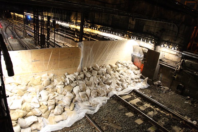
Crews have prepped the Lenox Terminal at 148th Street in advance of a potential storm surge. Photo: MTA New York City Transit / Leonard Wiggins
As water has begun to creep over the Battery, we’re in the not-so-calm before the worst of the storm and an accompanying surge hits the New York City area. Transit services have been offline since last night, and an eerie calm has descended over the city. Some people are out and about, and some local businesses are open. But right now, we’re just waiting for the worst to arrive.
The MTA though is not sitting idly by. They spent the night shoring up the system, and at a press conference with the Governor a few minutes ago, MTA Chairman Joe Lhota spoke about the risk to the system. Salt water, he explained, can have a very bad impact on the system. It can corrode switches “quite easily” and would seriously damage the signal system as well. Essentially, without switches and signals, the subways cannot run.

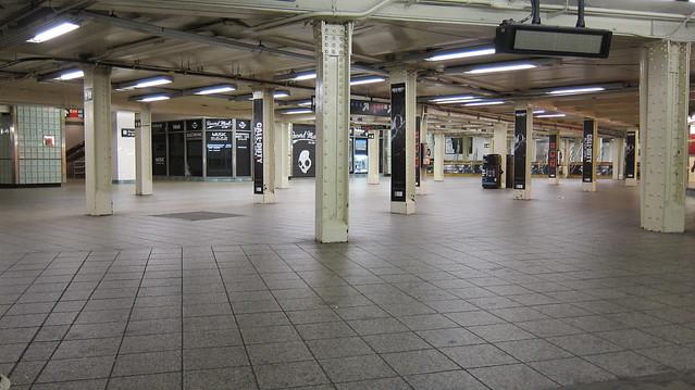
By 7:45 p.m., the mezzanine at Times Square was devoid of its usual hustle and bustle. Photo: Metropolitan Transportation Authority / Aaron Donovan
Last night, the MTA sent out a bunch of photographers to capture the system as it shutdown. We saw scenes of people rushing for the last train, an empty Penn Station, and Grand Central in its I Am Legend phase. People are at home as the storm strengthens.
As of now, the MTA has no plans to return subway service to normal until well after the storm passes. Once we’re in the clear weather-wise — which may still be 24-36 hours from now — crews will have to inspect the system for damage. I’ll have any updates as they emerge, but right now, the city that never sleeps seems to be taking an extended nap.

18 comments
If those barricades don’t hold, there will be a lot of questions about why greater measures were not taken after Irene. After all, lots of money was spent on security in the wake of 9/11. The status of the transit system will be the big issue most people in NYC face after the storm is over — the equivalent of power outages elsewhere.
We are broke across our society after 30 years of selling out the future. And the only solution anyone seems to have is to double down on selling out the future. But the future continues to arrive faster and faster.
Apparently the MTA actually *removed* — dismantled — a bunch of the switch motors and signal electronics, and is storing them above ground level, so that they can re-establish service more quickly after the floodwater recedes.
Now you know *why* the subway system had to close so early. Until New York gets a new, much larger floodwall, this was the most responsible thing to do.
Well that’s foresight. OTOH if the subway survives a big surge, the MTA will seem like a bunch of heroes. Either way, this is likely to be the story come Thursday. I’ll be able to bike in in any event.
Not to badmouth the MTA, but I don’t think they will have done enough. They have no way of knowing the unknown unknowns. As such, they will miss a few things (they are only human), and some service will take a long time to restore.
I’m 55 years old, and I only recall two planned full system shutdowns due to hurricanes – in part, because I didn’t use the subway when younger, and because we’ve had two storms in the past two years aim directly at the NYC region. And the MTA is learning from experience. I figure that it will take another big storm or two to have a reliable playbook to handle storms like these…. Let’s hope this playbook will never be needed again.
Well, this is only the second time it happened.
Anyway, let’s see if a pattern establishes. It’s not unlikely this is just how things are now.
The planning does seem to be better this time around, in the wake of Irene, but that’s usually how it goes — at least until there’s a long enough break in the action and people forget. The Lindsey Administration’s botching of the 1969 snowstorm made the city’s preparedness for future major blizzards a lot better … for 40 years. Then Mayor Mike’s people got complacent and you ended up with Snowbound on the A Train, which starts the cycle all over again.
I agree that there will definitely be “unknown unknowns”, and simply stuff they forgot. But they sure tried to prep.
I also doubt they removed all of the electronics. 🙁 I’m not even sure that’s possible. But at least it won’t be a *complete* loss.
Interesting…I was wondering why they started so early. I was on a train getting back to Penn at 8:45pm and I bolted to the subway just in time to see the last uptown A train pulling in. The turnstiles were already locked, so I had to jump over to catch the train. That was the strangest ride ever. I was the only person in the car, and the stations were completely empty and taped off. So eerie.
MBTA in Boston is closing now (as of 2pm). The Brooklyn-Batery and Holland Tunnel are closing at 2pm. The road system in Connecticut is closed to all but emergency traffic. Same as Delaware.
Basically, everything from Boston North Station to somewhere in Virginia is closed.
The storm is still 200 miles out to sea and STRENGTHENING.
This is the biggest single storm in North American history in terms of sheer size. I’m pretty safe up here in Ithaca, and *we* have wind warnings for this evening. (We’re getting thicker and thicker fog up here, so I’m already hunkered down; I’m not going out in fog with the wind knocking trees down.) Chicago now has 30-foot wave warnings (from the wind over the Great Lakes).
And you in New York City are going to get one of the worst hits — though not as bad as Connecticut, the New Jersey Shore, and Long Island. Currently, the wind is actually pulling the water south along the Jersey coast (though west in the area of LI Sound, then south). But as the storm hits the shore of New Jersey, the water is going to get shoved straight west and up the Hudson / Passaic / Hackensack. That’s when the surge is at its maximum in NY, CT, and most of the NJ coast. The LI Sound is going to get the worst surge.
It’s worse to be on the Jersey Barrier Islands, though. At this point most people still there can’t leave because there’s water west of them, but they may be completely flooded, and then the hurricane-force winds will hit. Atlantic City will get the eye of the hurricane. And it’s already under water.
FYI, this storm — Sandy — is directly due to global warming.
Not just because the hotter ocean temperatures made it more powerful — but because the lack of Arctic sea ice created the upper atmosphere “block” which drove the storm towards New Jersey rather than out to sea.
Please never speak of meteorology ever again. The “block” is caused by a high pressure system currently over the North Atlantic and Canada. Hurricanes are low pressure. High and low pressure have winds that go in opposite direction (counter clockwise in a low clockwise in a high) These systems push each other apart and a Blocking high has very little if any movement, whereas Sandy was moving so the high prevented it from going out to sea. These high pressure systems from naturally and have absolutely nothing to do with Global Warming.
-A Meteorologist
These guys blame everything on global warming
Sanny Glover blamed the Haiti Earthquake on GW
I thought a link between global warming and earthquakes sounded absurd — until I did my research, which you clearly didn’t:
http://www.rawstory.com/rs/201.....fts-study/
Turns out there probably is a link. Interesting, isn’t it?
The unusual and atypical high pressure system over the North Atlantic in late October was encouraged by, uh, lack of Arctic sea ice, last I checked.
You can call it “natural” if you like, it’s still caused by global warming.
Please never pretend to be a meteorologist again.
And I don’t particularly care if you have a degree, you appear to one of those people with “a little knowledge”, which is a dangerous thing.
For the peanut gallery:
“The loss of sea ice opens large expanses of open water, which absorbs more of the incoming solar radiation and adds heat and moisture to the atmosphere, thereby helping to alter weather patterns. Exactly how weather patterns are changing as a result, however, is a subject of active research.
While it is not unusual to have a high pressure area near Greenland, its intensity is striking for this time of year. As Jason Samenow of the Capital Weather Gang wrote on Wednesday, the North Atlantic Oscillation, which helps measure this blocking flow, “is forecast to be three standard deviations from the average — meaning this is an exceptional situation.”
http://www.climatecentral.org/.....andy-15157
Yeah, this is pretty basic meteorology. Global warming -> less sea ice -> more intense high pressure zone in the north Atlantic -> hurricanes pushed west in the north Atlantic. I dare you to find a better hypothesis.
I am relaxing it out on the beach in Queens, NY. I’ve been through worst storms in the South, where we have hurricanes and tornadoes ALL the TIME………….