
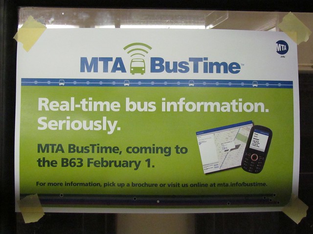
The real-time tracking solution for the B63 has been developed in house by the MTA. (Photo by Benjamin Kabak)
Within its 2011 agenda, the MTA promised to bring real-time bus tracking to every single bus under its purview on Staten Island. For those who have been charting the MTA’s bus-tracking project, this is a seemingly bold promise to put to paper. After fits and starts due to GPS compatibility issues, the authority had managed to install Clever Devices’ costly Bus Tracker program on only the M34 and M16, but the costs for that project proved too great for city-wide adoption. And so the MTA turned in-house for a solution.
This week, Transit will unveil that in-house solution, as the agency’s bus time tracking system will be live on the B63 in Brooklyn. The new system will follow buses as they run from Pier 6 at the Brooklyn Bridge Park to the southern terminal near the Verrazano Bridge and back. While the signs in the buses say the debut will be today, the official launch is still a few days away, and when the project is ready, it will be live on the MTA’s website at http://bustime.mta.info/.
Last week, I took a tour of a bus at the Jackie Gleason depot with Michael Frumin, a senior strategic analyst with the MTA. Frumin, known for, among other things, his subway spark lines, has been working to develop an open-design approach to real-time tracking that comes at a lower cost than the Clever Devices’ implementation and allows the MTA more freedom with its data. He and I had a talk about the new bus tracking equipment and the MTA’s thinking behind an open source approach.
The main problems with the Clever Devices’ system concern its proprietary nature and its cost. For the MTA to install Clever Devices’ computer, it must either upgrade old buses as a relatively high cost and maintain a closed computer network. At one point, the authority had estimated that it would take at least $140 million and five years just to install Clever Devices’ system through the city, and even then, the software and hardware handcuff the agency. Only Clever Devices can run software on its own hardware, and only Clever Devices can control the data flow. We’ve seen the limitations of the MetroCard technology, and the MTA wasn’t keen on pursuing a lengthy and expensive contract with another proprietary company.
So the MTA instead went the open-source route. Working with OpenPlans, the non-profit behind Streetsblog, on a $265,000 software-development contract, the MTA went about setting up its own system. On the hardware side, the set-up is simple. Using much of the same technology that will one day be installed as card readers for the next-generation fare payment technology system, the bus tracking uses a wireless moden, a power conditioner, a highly-secure on-board computer and a GPS device with dead reckoning to track the bus.
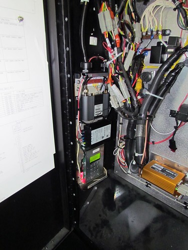
A glimpse at the technology behind the MTA's new BusTime set-up. The GPS device, right, hooks into an internal computer with a power conditioner and wireless modem. (Photo by Benjamin Kabak)
At the outset, the device relies on the driver to input data that he must input at the start of every route and when the bus turns around. By hooking the computer up to the bus route sign, the bus’ initial direction is sent to the software. For example, when a B63 leaves the Jackie Gleason Bus Depot and the driver arrives in Ft. Hamilton, he’ll set the sign to say that the B63 is Cobble Hill-bound. The internal computer will read the direction, and with data from the GPS, it can calculate the direction and location of the bus as it travels its route. The Clever Devices’ system relies on schedule data and other complex calculations to derive location.
Of course, as with any less expensive and open system, the data won’t be as complete as that offered by Clever Devices. With its in-house bus tracker, the MTA can present at the outset how far away the bus is from its location but not how many minutes away from a certain stop the bus will be. Frumin told me that it is a goal to develop an accurate prediction algorithm for travel times.
Meanwhile, because this new system is open-source, the MTA can open it up to developers. It will issue an API and allow New York’s myriad transit programmers to take a crack at the data. Frumin spoke to me about possible uses. Someone could develop an SMS alert system or a do-it-yourself countdown clock that auto-refreshes based on the BusTime information. CEMUSA, the owner of the bus stops, could, for instance, install its own timers even as the data remains available online. Essentially, with this open source approach, when you need to add features or want to borrow what others are doing, it’s quite easy.

A screenshot of the B63 BusTime tracker as it will appear online. At press time, a larger image was not yet available.
So what’s next? It seems clear that while the internally developed BusTime will make its debut in Brooklyn, Staten Island will be the real testing ground. Can an entire borough’s bus fleet be viewed at one time? Will the MTA run into GPS-based problems as it eyes Manhattan? Dead reckoning should fix that problem, but it’s much easier to implement location-based technology along 5th Ave. in Brooklyn than along 5th Ave. in Manhattan.
For now, though, we’ll see in-house development in action. The MTA will have the chance to show us that it can develop real-time tracking for cheaper than a closed-source market leader. For a giant transit provider seemingly afraid of technology five years ago, that is a step in the right direction.


 As Jay Walder gets more comfortable in his role as the new CEO and Chairman of the MTA and as he realizes what kind of power he might wield while relying on his Golden Parachute, he has spent much of this week discussing his future plans for the MTA. He knows that the agency needs to
  As far as public transit imagery goes, London’s buses are among the more iconic vehicles in the world. The


 A Note on the Weather: Supposedly, New York City is in for up to a foot of snow by the time the morning rush hour kicks off on Monday. New York City Transit is well aware of the impending snow, and Paul Fleuranges, the corporate communications V.P. at Transit, sent out an e-mail this evening detailing the agency’s plans.