
The new MTA website is now live. I’ll have a full report on it when I’m through my current class shortly after 4 p.m. Stay tuned for more. Updated: The full report is now available right here. [MTA.info, SAS’ take]
 Since the MTA announced plans to cut the Student MetroCard program, I’ve written extensively about the various aspects to this threat. We’ve explored the politics of the cuts and the mathematics behind the impending death of free student rides. Last week, Assembly rep Richard Brodsky promised to fight for student funding, and today we learn just how much it will take to save the program.
According to an article in today’s Daily News, the MTA will need $214 million from the government to maintain free student MetroCards. This total covers the entire cost of the program in 2009 dollars to the MTA as shown in this graph and would represent a significant contribution to the MTA during an era in which the state and the city have both pulled back on subsidies to transit.
The News reports that the MTA will scrape the program if the city and state do not fund it in its entirety, and recent comments by MTA CEO and Chairman Jay Walder support that sentiment. “It’s my aspiration that children in this city should be able to ride free to go to school,” he said last week. “It’s up to the state and city to put together a funding package to allow that to happen.”
In Albany, Gov. David Paterson has said he will unveil a new budget with more money for student travel within the next two weeks. Can we really expect the cash-strapped state to find $208 million more than they pledged for 2010 for student travel? After all, just under two months ago, the state cut its student subsidies from $45 million to $6 million, and so far, the city has been awfully quiet on the student travel front.
In the end, I’m left with the same position I’ve held since the beginning. It is unpopular for the MTA to threaten free student transit, and it will create more ill will toward the embattled authority. But the political response to this move from the elected officials in Albany shows that the MTA played the right card. No one has been able to justify foisting the expense of student travel on the transit authority, and politicians are scrambling to find the dollars for it. I wouldn’t be surprised to see the state and city come up short, and when they do, the MTA will have to decide who should pay: students through a half-price fair or the rest of us through a series of inconvenient service cuts. I know what I’d choose. Do you?
 When the MTA threatened to implement its Doomsday budget a year ago, the cuts — as this PDF shows — were substantial. The agency planned to do away with the W and Z trains, roll back the M to Bay Parkway, shutter some Lower Manhattan stations and generally reduce headways all around. Buses had a it worse with 26 scheduled for a flat-out elimination while numerous others would see weekend and late-night service reductions or cuts.
A year ago today, the agency held its first of eight planned public hearings on the service cuts, and the situation looked dire. The MTA had to close a budget gap of over $1.2 billion that, at one point, was rumored to increase to nearly $1.8 billion. Albany, meanwhile, was stalling on a proper funding package. In a real sense, the situation in 2009 is far from that facing the MTA today in 2010.
This year, the MTA is attempting to close a budget gap much smaller. By all accounts, the gap is between $300-$400 million. It could, if the MTA so chose, easily be covered by a small fare increase, but the agency promised Albany it would not raise fares again until a planned 2011 adjustment for inflation. The body politic could not stomach three or four consecutive years with fare increases. Yet, the media has made the mistake of assuming that last year’s Doomsday budget is the same as this year’s.
In countless stories and reports, those covering transit have talked about Doomsday cuts as though they are back. They mention subway and bus route eliminations as though the MTA will just graft last year’s plan onto this year’s problem. At the start, I too was guilty of this sin, but I’ve realized that the MTA has a different plan in the works. Yesterday, we looked at how the V train could be replacing the M train in north Brooklyn, and today, MTA sources reveal another change to the 2009 Doomsday service cuts.
According to the Daily News, some local bus routes originally believed to be on the block may be spared. Says Pete Donohue:
The Bx34 in the Woodlawn section of the north Bronx and the B25, which runs through East New York, Fort Greene and Brooklyn Heights in Brooklyn, are among the local routes that will be saved under the revised plans, sources said. The Bx10 in Riverdale and Norwood also gets a reprieve, sources said.
But while transit officials have decided to spare some local bus riders, other commuters will be affected, sources said. Additional express bus routes – the most expensive to operate – are likely to be targeted for elimination. Most express buses run between Staten Island and Manhattan.
Donohue’s report seemingly jibes with the story about the elimination of the X32. Although that bus — and many other express offerings — was originally slated for the chopping block last year, the MTA seems to have a more refined approach to the service cuts and adjustments. Instead of trying to do the most to save a lot of money, the agency is looking at cost-effective approaches. That very same X32 is a great example. Between Labor Day and the end of November, that bus carried just 50 people per day at a per customer cost in excess of $50. Even with the Express Bus fare, the MTA is simply bleeding money on those rides. Why keep that bus route and similar ones to it in service?
Right now, we’re simply left waiting. The MTA was legally required to pass a balanced budget in December, and the approved then featured numerous service cuts carried over from last year. By now, though, it’s clear that the agency will revamp its proposed eliminations, and until then, we should reserve judgment on their respective impacts. We know late-night bus riders, express bus customers and some straphangers will be left out in the cold, but we don’t know which ones that will be quite yet.

A new entrance to the catacombs of Grand Central Terminal will open in Sept. 2011. (Rendering courtesy Metro-North)
In a sense, the East Side Access Project is New York City’s forgotten big construction effort. While the Second Ave. Subway construction is disrupting street traffic and residential life along the Upper East Side, the East Side Access work continues daily far below the surface of the city. Slowly, the benefits of this project will soon be coming online, and Metro-North announced yesterday the construction of a new entrance to Grand Central Terminal as part of the East Side Access work.
This new entrance, set to open in September 2011, will extend the Grand Central entrance options north to 47th St. The street-level access point will be on the side street between Lexington and Park Avenues in the building at 245 Park. The new entrance will feature an escalator from the street to the 47th St. cross passageway and a staircase from the street to the platform shaed by Tracks 11 and 13. Right now, the east end of the 47th St. cross passageway has no outlet.
“This new entrance will be a tremendous benefit to both current Metro-North customers and future LIRR customers by providing a fifth northern means of ingress and egress to the trains,” Metro-North President Howard Permut said in a statement.
“This entrance is an example of how construction can be staged so that customers can enjoy incremental benefits as each element of a project is completed,” MTA Capital Construction President Dr. Michael Horodniceanu said.
Currently, the 47th Street cross passage runs directly below street level from Lexington Avenue to Madison Avenue and has staircases that lead to every train platform on the upper level of Grand Central. From that passageway, commuters can use two walkways to reach the 45 St. cross passageway and connect to all lower level platforms. With these options, those who work north of Grand Central save, according to Metro-North, up to 15 minutes of walking time.
As crews work to build this new entry way, Tracks 11 and 13 at Grand Central will be out of service. The MTA must extend Track 13 south due to the loss of space to escalators and stairs on the northern end of the platform, and to keep a platform 10 cars long, a southern extension is necessary. Metro-North began this work yesterday, and it is due to cost $14 million over the next 20 months. When the East Side Access work is completed in 2016, the LIRR concourse will connect to the 47th St. passageway as well.
Over at his Ink Lake blog, Friend of Second Ave. Sagas Peter Kaufman has up a post on the various styles of subway conductor. Riffing a famous picture of Clint Eastwood, Lee Van Cleef and Eli Wallach, Kaufman highlights the three personalities of those in charge of getting passengers onto and off the trains while keeping to a demanding schedule. The Good is one who “opens the doors promptly at the station, and doesn’t shilly-shally when closing. If someone on the platform hesitates, their decision is made for them. The doors are closed, and the train is on its way.” The Bad are those who are overly considerate. These are the ones who allow passengers to just catch the train, but as Peter writes, the delays can add up to make trips 15 percent longer than scheduled. The Ugly are those who “try closing the doors even as people are still exiting the train, let alone anyone boarding.”
I’ve seen them all, and in a way, Kaufman’s simplified view of conductors really nails it. Of course, sometimes the Bad are held hostage by riders holding the doors, and sometimes the Ugly are just trying a bit too hard to keep their trains running on time. A good conductor will have his or her timing down just right, and for those people running to make the train, well, there’s always “another one directly behind us.”
 As the MTA adjusts the planned service cuts to better meet customer demands, a novel use for the Chrystie St. Connection between the IND and the BMT at Essex and Delancey Sts. may be in the cards. According to a few message board posters and now Heather Haddon’s “transit sources,” the MTA may adjust the route of the V train to subsume the current M route out to Metropolitan Ave. This new route could alleviate some pressure on the L line and provide an indirect one-seat ride from parts of Brooklyn and Queens that just aren’t that far apart.
Over the last few days, I’ve been checking in on some of the message board chatter concerning the upcoming service cuts. Last week at the NYC Transit Forums, frequent poster Zman started a thread about a potential merging of the M and V lines. He said:
The TA is considering eliminating the M and sending the V to Metropolitan Av via the Chrystie St Cut if the doomsday cuts aren’t head off at the pass. This would mean that the V could only run 8 car trains. This could start in late June.
Logistically it would be a little difficult unless they took some of the 60 foot SMEE’s that are mothballed and put them back into service, or if ENY has enough 4 car unit 160’s to cover service since 46’s can’t run on the Williamsburg Bridge. For passengers though, this sounds like a good deal.
It’s in the talking stages and nothing is official yet.
Subchat picked up the news a short time later, and the subsequent discussion has been rather lively. Today, amNew York, citing only “transit sources,” joins the chorus. The M is scheduled to be scaled back from its current peak-hour run into South Brooklyn through the Montague St. tunnel and along the BMT Fourth Ave. and West End Lines, and this rumored cut would, in effect, kill the line.
So how would this work? Transit would run eight-car sets along the V from Forest Hills along its current route along the IND Queens Boulevard line via the 53rd St. tunnel to the IND Sixth Ave. line. After stopping at Broadway-Lafayette, the train would then take the Chrystie St. Cut, shown in in this track map, to the current J/M/Z BMT Nassau St. stop at Essex/Delancey Sts. The V would then run over the Williamsburg Bridge and up to Metropolitan Ave.
In a way, this makes sense. Once the M is scaled back from its southern extension into Brooklyn, the train will operate mainly as a spur to Metropolitan Ave. with peak-hour service to Lower Manhattan. Here, Transit would replace that M service with a line that serves Midtown. Although some Lower Manhattan-bound riders would have to transfer to the J, those heading to Williamsburg and points east could take a one-seat ride on the V and, ideally, avoid the L.
Right now, Transit and the MTA are still working to formulate a plan for the service cuts, but when everything is finalized later this year, we could see some changes to the subway map. I wouldn’t be surprised to see revenue service restored to the Chrystie St. Cut as long as the numbers work out.
When the MTA gets around to cutting service later this year, many New Yorkers — particularly those who rely on late-night bus service and off-peak transit options — will find themselves facing fewer options and longer commutes. In The Times this weekend, Ariel Kaminer tried to find out just how long these new commutes will take, and her article takes this experiment to an extreme. Kaminer asked HopStop’s CEO to find her a long route made longer by the death of the X32, and he routes her from “DeKalb Avenue in the Bronx, up near Woodland [sic] Cemetery, to 26th Avenue in Queens, not far from Fort Totten and Little Neck Bay.” As the crow flies, this is an 11.7-mile trip over the Throgs Neck Bridge, but for transit riders generally, it is now a one-transfer ride that involves a 4 or a D and the QM2A express bus.
Ultimately, Kaminer’s convoluted alternate route took her on a bus, a Metro-North train, a subway and a Long Island Rail Road train. It took nearly three hours and was designed to highlight what might happen if the X32, a route designed to ferry Bronx Sciences students to and from Queens is eliminated. The problem is that this route isn’t really indicative of anything. The MTA hasn’t yet determined if it will eliminate an important school route, and the vast majority of New Yorkers will be impacted in other, less absurdist ways by the transit cuts. Anyway, Kaminer’s route is well beyond that of the X32.
Articles such as this one make me question the “why” of it all. Is picking an obscure route that few use from one area of the Bronx to an already transit-poor area of Queens get the point across? Didn’t the piece highlighting late-night bus riders do so more effectively? There are far more tangible ways to highlight the impact of the service cuts particularly for those who do not commute into and out of Manhattan at peak hours. This was just an extreme travel stunt.

Kicking and screaming, the New York City bus network will be dragged into, well, the present. The 34th St. route features countdown clocks for buses, and the MTA and the city’s Department of Transportation are working together to plot the rollout of Select Bus Service throughout the five boroughs. None of this will work, though, without proper bus lane enforcement.
Last week, while speaking with Richard Brodsky and the Assembly Committee on Corporations, Authorities and Commissions, MTA CEO and Chairman Jay Walder started beating the drum again for bus lane enforcement. In interviews shortly after he received the MTA nomination, Walder stressed the need for these cameras, and he was at it again last week.
“I simply don’t think that the MTA ever made bus lane cameras a priority. In fact, I don’t think the MTA has made buses a priority quite the way that we’re doing today,” he said. “One of the things that I’ve tried to say from day one is that buses are an under-utilized, untapped resource in New York. We can do much more with it, and we’re making it our priority to do that.”
Of course, the State Assembly has long been a reason why the city has not yet implemented bus lane cameras. Back in 2008, David Gantt, a Rochester Democrat, torpedoed a home rule measure that would have allowed the city to use cameras to enforce the bus lanes. Since then, however, the Assembly has ceded ground on red-light cameras, among others, and Walder is optimistic that they will allow for proper bus lane enforcement as well. “I recognize the issues about privacy,” Walder said. “The Assembly, the legislature, has gotten over those issues with red light cameras. There’s no reason why we can’t get over those issues with the bus lane enforcement cameras.”
Meanwhile, a City Council measure could slow down the DOT/MTA bus lane efforts as well. At the end of the year, according to a recent Streetsblog report, the City Council passed a bill mandated a 65-day review period for all “‘major realignments of the roadway,’ particularly the addition or removal of a lane of traffic or parking on more than four blocks or ‘1,000 consecutive feet of street.'”
This move is one designed to allow for more community input in DOT roadway planning, but DOT is not bound to alter plans in the face of community reaction. On the one hand, this law should eliminate any sense of paternalism that may stem from DOT unilaterally deciding how the streets should be laid out without consulting businesses and community boards. On the other, vocal minorities who seem to obsess more about parking than they should may earn too much of a say in the process. Streetsblog isn’t concerned that this measure will materially impact too many DOT plans.
In the end, these two efforts — camera enforcement and the need for dedicated lanes — highlight what is missing from the Select Bus Service plan and what the city needs to have a truly effective higher-speed bus network. I’ve seen cars driving down the 34th St. in the new bus-only lanes, and I’ve seen buses stall traffic when they have to navigate around double-parkers and other vehicles idling in bus lanes. Without dedicated lanes and without an effective enforcement means for those lanes, buses will be subject to the whims of New York City’s painfully slow surface traffic.
Walder knows that better bus service is both cheaper and more immediate than building out new subway lines. He knows that buses can be deployed to bring people into the city’s central business districts or to subway hubs. Right now, we view the buses are an inconvenience that can sometimes get us where we need to go but are mostly utilized by the aged and infirm who can’t negotiate subway staircases. In a few years, buses can be an accepted part of the city’s transit network, and with true bus lanes and enforcement measures, that vision could be one step closer to reality.

Forget CBTC subway cars with air brakes and automated announcements. Forget countdown clocks and contactless fare payment cards. This news tonight — news that the MTA will unveil a redesigned and updated website on Wednesday — is, ladies and gentlemen, the surest sign that the agency is starting to get serious about technology.
Since 2003, the MTA’s website has received nary an update. Web 2.0 with all of its interactivity and customer interaction took over the Internet, and the MTA’s site remained materially similar to its late-1990s iterations. Since I’ve started blogging in November 2006, we’ve seen the MTA’s site suffer through some growing pains. A July 2007 power outage that curtailed service along the East Side IRT and sent users to the agency’s site led to an outage, and the August 2007 flood and subsequent traffic spike knocked out the agency’s site as well.
Meanwhile, the agency’s regional and national competitors have recently unveiled new site designs. In Washington, the WMATA’s site redesign earned rave reviews, and recent NJ Transit and Port Authority site overhauls have also been well received. Still, the MTA’s site, a mish-mash of boxes and links and agencies, lumbered ever forward.
When new MTA CEO and Chairman Jay Walder assumed the reins in October, he knew he wanted to overhaul the agency’s site, and this week, in conjunction with his first 100 days in office, Walder will flip the switch on a new site. “We’re not cutting-edge; let’s not kid ourselves. But we’re getting closer,” Walder said to The Times today. “The idea here was not to break new ground; the point was to provide good service to our customers. Customers want to be able to find out how to get from point A to point B; they want to see right away whether or not the train or the buses they’re looking to get on are on schedule.”
The MTA’s site is popular, second only to Amtrak among the nation’s transit providers. At its peak, the agency sees 1.8 million unique users per month and over 25 million page views. Now, it will be better, and Michael Grynbaum offers a first look:
Real-time information on delays and service interruptions — difficult if not impossible to find on the current site — is the first thing that catches a viewer’s eye. A widget on the home page compiles continually updated service status for every subway, bus and commuter rail line in the region, along with nine of the bridges and tunnels operated by the authority.
The information is color coded (red for delays, green for good service) and divided into categories (subway, rail, bus) by tabs, similar to a Web browser that allows users to toggle through multiple pages. At a glance, readers get a sense of whether the F train back to Carroll Gardens, Brooklyn, for instance, will be smooth sailing or an underground maelstrom.
Also prominent on the new home page is a feature called “Plan & Ride,” which lets users find door-to-door directions across several modes of transportation. The feature is similar to HopStop.com and the authority’s own TripPlanner application, although entering a search sends users directly to a Google Maps page…
The authority already licenses its scheduling data to Google, and Mr. Walder said that it made more financial sense to take advantage of an already popular outside service rather than to continue investing in a proprietary application.
The new site, says The Times, will also “make it easier for outside software designers to get free access to system timetables and routes.” The MTA has long been criticized for its approach to scheduling data and other route information, and I recently wondered when the authority would catch the open information bug. The answer, it seems, is soon.
When it goes live, the new site will still be a work in progress, and some web designers wish it could be “sexier.” Still, mobile versions for Blackberry and iPhone are in the works, and Transit has embraced Twitter. I’ll have a full review of the new site when it goes live, but I’m very encouraged by this news. A website redesign has been a long time coming for the MTA, and it shows a commitment to communication and customer service that had been, for a few years, lacking. Hopefully, this new site design is a sign of things to come.
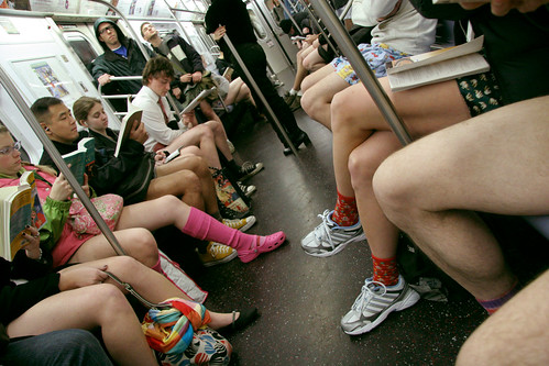
Ah, January. It’s a brisk time of year for New York. The temperatures are hovering in the low 20s, and people ride the trains bundled up in layers of coats and sweaters. Yet, for one group of fun-loving New Yorkers, January is also the time for the No Pants Subway Ride.
For the last eight years, the instant-comedy group Improv Everywhere has hosted the No Pants Subway Ride in New York City, and this afternoon, unsuspecting straphangers will witness the ninth No Pants Ride. Last year, 1200 people dropped trou on the trains, and even more are expected later today.
So here are the details for this year’s event. For the first time in the history of this voyeuristic event, Improv Everywhere will tackle the outer boroughs. Those who wish to participate should meet at the following locations at 3 p.m.:
Astoria: Meet at Hoyt Playground
Downtown Brooklyn: Meet at Prospect Park
Downtown Manhattan: Meet at Foley Square
Queens: Meet at the Unisphere in Flushing Meadows Park
strong>Uptown Manhattan: Meet at the Great Hill in Central Park
Williamsburg / Bushwick: Meet at Bushwick Park (AKA Maria Hernandez Park)
The event will culminate in a pants-less gather at Union Square shortly after. At around 4 p.m., the Union Square area should be teeming with too many people wearing only underwear and exiting the subway.
I won’t be participating this year. Two years ago, I joined my one and only No Pants Subway Ride at a time when around 900 other people joined me. At that point, enough New Yorkers didn’t know what was happening for the ride to be a gimmicky and funny and novel. Now, though, at least 1500 people will arrive, and nearly everyone is expecting someone to take his or her pants off this afternoon.
If you’re riding the rails and see it happening, enjoy the absurdity. If you’re participating, good luck. For the rest of us who may just be trying to get from Poitnt A to Point B, well, good luck with that too.